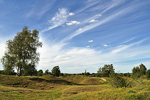
Barnack Hills & Holes
Barnack Hills & Holes is an area at the edge of the village of Barnack in Northamptonshire, in the north-eastern part of the county known as the Soke of Peterborough. It covers 57½ acres and is a biological Site of Special Scientific Interest.
Hills & Holes was a quarry site from time immemorial until about 1500. From here was drawn the distinctive, deep honey-coloured limestone known as Barnack Rag used to build Peterborough Cathedral and Ely Cathedral, and the houses of the pretty villages of the Soke including Barnack itself. Since the quarry was abandoned, the area has reverted to nature; the scarring of the mediæval workings suggesting the name "hills and holes".
Conservation
- Location map: -0.412/zoom=11 52°37’44"N, 0°24’43"W
- Streetmap: TF075046
The site has been designed as:
- A site of special scientific interest.[1][2]
- A national nature reserve.
- A Nature Conservation Review site, Grade I.[3]
- A Special Area of Conservation, to protect the orchid rich grassland as part of the European 'Natura 2000' network.[4]
Arising from the rubble of a mediæval quarry, the Hills and Holes is one of Britain’s most important wildlife sites. Covering an area of just 50 acres (22 ha), the grassy slopes are home to a profusion of wildflowers. This type of meadowland is now all too rare; half of the surviving limestone grassland in Northamptonshire is found here.
The unique hummocky landscape was created by quarrying for Barnack Rag, a valuable stone first exploited by the Romans over 1,500 years ago. Most famously, stone from Barnack was used to build the cathedrals of Peterborough and Ely. By the year 1500 however, all the useful stone had been removed and the bare heaps of limestone rubble gradually became covered by the rich carpet of wildflowers that can be seen today.
Barnack’s rich flora supports a wide variety of wildlife, especially insects, and a number of nationally scarce species are found. Limestone grasslands are traditionally grazed with sheep and at Barnack, grazing is carried out in autumn by up to 300 sheep. These remove the summer growth and build-up of leaves, stalks and grass tussocks that would otherwise die back to form a dead layer, or litter, on the ground. Without grazing, the build-up of coarse grasses and litter would rapidly choke the rarer lime-loving plants.[5]
Outside links
| ("Wikimedia Commons" has material about Barnack Hills & Holes) |
References
- ↑ SSSI listing and designation for Barnack Hills & Holes
- ↑ "Map of Barnack Hills & Holes". Natural England. http://magic.defra.gov.uk/MagicMap.aspx?startTopic=Designations&activelayer=sssiIndex&query=HYPERLINK%3D%271001564%27. Retrieved 28 November 2016.
- ↑ Ratcliffe, Derek, ed (1977). A Nature Conservation Review. 2. Cambridge, UK: Cambridge University Press. p. 138. ISBN 0521 21403 3.
- ↑ Barnack Hills and Holes SAC Joint Nature Conservation Committee
- ↑ Rollins, Julian: 'Land Marks: Impressions of England’s National Nature Reserves' (English Nature, 2003)
