Ballyscullion
From Wikishire
| Ballyscullion Irish: Baile Uí Scuillín | |
| County Londonderry, County Antrim | |
|---|---|

| |
| Location | |
| Location: | 55°8’17"N, 6°56’49"W |
| Data | |
| Post town: | Magherafelt |
| Postcode: | BT45 |
| Dialling code: | 028 |
| Local Government | |
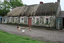
Ballyscullion is a small village and parish in County Londonderry. In the 2001 Census it had a population of 291 people. The parish additionally extends into County Antrim.[1] The name is from the Irish ‘’Baile Uí Scuillín’’, meaning “Ó Scullín's townland”.
People
Increase Mather served as a minister at St Tida's Church, Ballyscullion in the late 1650s until 1659. Frederick Hervey, 4th Earl of Bristol, known as "The Earl-Bishop", was Bishop of Cloyne from 1767-68, and as Bishop of Derry from 1768-1803. He built Downhill House and Ballyscullion House, residences which he adorned with rare works of art.
| ("Wikimedia Commons" has material about Ballyscullion) |
References
- ↑ "Parishes of Northern Ireland". Public Record Office of NI. http://applications.proni.gov.uk/geogindx. Retrieved 30 December 2012.
Outside links
- Profile, NI Neighbourhood Information System
- Profile, DiCamillo Companion to British & Irish Country Houses