Atherstone
| Atherstone | |
| Warwickshire | |
|---|---|
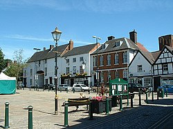
 Atherstone Market Square | |
| Location | |
| Grid reference: | SP3098 |
| Location: | 52°34’43"N, 1°32’46"W |
| Data | |
| Population: | 8,293 (2001) |
| Post town: | Atherstone |
| Postcode: | CV9 |
| Dialling code: | 01827 |
| Local Government | |
| Council: | North Warwickshire |
| Parliamentary constituency: |
North Warwickshire |
Atherstone is a town in northern Warwickshire. It is found near the northernmost tip of the county, close to the borders of Staffordshire and Leicestershire. Here the River Anker forms the boundary between Warwickshire and Leicestershire, which for the most part is marked by Watling Street.
The town is 5 miles northwest of Nuneaton and 13 miles north of the nearest major city in the county, Coventry. Witherley village is on the opposite bank of the river in Leicestershire, whilst the village of Mancetter is contiguous with Atherstone to the southeast.
Atherstone had a population of 8,293 at the 2001 census.
Contents
History
Atherstone has a long history dating back to Roman times. An important defended Roman settlement named Manduessedum existed at Mancetter near the site of modern-day Atherstone. The Roman road known as Watling Street, whose route is followed by the A5, ran through the town. It is believed by some historians that the Battle of Watling Street was fought near 'Manduessedum, at which battle the Romans defeated Boudica Queen of the Iceni and ended the "Great Rebellion" against the Roman tyranny.
The Domesday Book of 1086, records that Atherstone was held by Godiva,[1] the Lady Godiva of legend.
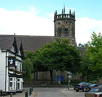
The ancient St Mary's Chapel in Atherstone dates from the early 12th century when the monks of Bec made a donation of 12 acres to a house of friars and hermits, later referred to as “Austin friars”. According to Nichols the chapel was granted to Henry Cartwright in 1542, then left abandoned and neglected until 1692 when Samuel Bracebridge settled a yearly sum for the parson of Mancetter to preach there every other Sunday in the winter season[2]
After this, St Mary's Chapel seems to have experienced something of a revival. Its square tower being rebuilt in the Gothic style in 1782. This drastic alteration probably aroused some controversy. although the fine architectural drawing of the chapel made by Mr. Schnebbelie in 1790 prompted Nichols to assert that “the new tower provides a good effect”. St Mary's was further redesigned in 1849 by Thomas Henry Wyatt and David Brandon.[3]
The Battle of Bosworth was fought close by; some historians believe that it was fought in the fields of Merevale above Atherstone in 1485 as reparation was made to Atherstone after the battle and not to Market Bosworth, but archaeology in 2012 placed the battle at a field east of Stoke Golding in Leicestershire, close by.[4]
The Tudor dynasty began with the victory on Bosworth Field. In Tudor times, Atherstone was a thriving commercial centre for weaving and clothmaking. The town's favourable location laid out as a long ‘ribbon development’ along Watling Street, ensured its growth as a market town. While it remained an agricultural settlement in mediæval times, attempts were made to encourage merchants and traders through the creation of burgage plots, a type of land tenure that provided them with special privileges. A manuscript discovered by Marjorie Morgan among the muniments of Cambridge’s King's College (Ms. C9), refers to the creation of nine new burgage strips from land belonging to seven of the tenants in Atherstone vill.
By the late Tudor period Atherstone had become a centre for leatherworking, clothmaking, metalworking and brewing. Local sheep farmers and cattle graziers supplied wool and leather to local tanners and shoemakers (an industry that continued until the 1970s), while metalworkers, locksmiths and nailers fired their furnaces with local coal and the alemakers supplied thirsty palates on market days.
The surviving inventories from 16th-century Mancetter provide a fascinating glimpse into Atherstone’s Elizabethan merchants and traders, before the town was economically overshadowed by the bustling city of Coventry. They show Atherstone at this time as a typical Midlands market town, taking full advantage of its location and agricultural setting.[5]
Hat industry
Atherstone was once an important hatting town, and became well known for its felt hats. The industry began in the 17th century and at its height there were seven firms employing 3,000 people. Due to cheap imports and a decline in the wearing of hats, the trade had largely died out by the 1970s with just three companies remaining, Denham & Hargrave Ltd, Vero & Everitt Ltd, and Wilson & Stafford Ltd. The production of felt hats in the town ceased altogether with the closure of the Wilson & Stafford factory in 1998.
Economy
In part due to its central location in Britain (on the main A5 national route and close to the M42 motorway), Atherstone's economy has expanded rapidly since the 1990s, with several major companies setting their head office operations and/or national distribution centres up in the town.
Transport
The Coventry Canal and a series of eleven locks runs through the town, as does the West Coast Main Line railway. Atherstone has its Atherstone railway station|railway station on this line, with an hourly service 7 days a week to both London and Crewe by way of Stafford and Stoke.
The historic station building, built in 1847, was under threat of demolition in the early 1980s. Thanks to a local group, the Railway and Steam Traction Society, listed status was obtained, with the building celebrating its 150th anniversary in 1997. Building work won a special Ian Allen conservation award. As of 2008, the station building is occupied by a local veterinary practice.
Recreation
- Football: Atherstone Town FC, known as 'The Adders'. Their ground is located on Sheepy Road.
- Rugby union: Atherstone Rugby Football Club. Their ground is at Ratcliffe Road.
Atherstone Leisure Complex is at the north end of Long Street and consists of a swimming pool and gym. Atherstone Memorial Hall is also part of the leisure complex.
Shrovetide Ball Game
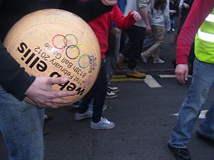
An annual tradition in Atherstone is the Shrove Tuesday Ball Game played on a public highway with large crowds. The game celebrated its 800th anniversary in 1999.
The game is a complete free-for-all played along Watling Street (the old Roman road) at the point where it forms the main street of Atherstone town. The ball is decorated with red, white and blue ribbons that are exchanged for money by who ever is able to obtain one and is made of thick leather to make it too heavy to kick far. The match starts at 15:00 when the ball is thrown from the window of Barclays Bank and continues until about 17:00. However the ball may legitimately be deflated or hidden after 16:30. There are no teams and no goals, though in the last century the match was played between a team from Warwickshire and one from Leicestershire. There is only one rule: players are not allowed to kill one another. Whoever is able to hang onto the ball at the end of the game not only wins the game but is allowed to keep the ball as well.
This Shrove Tuesday ball game has been held annually since the early 12th century and is one of Atherstone's claims to fame. The origin of the game, in the reign of King John, is thought to have been a "Match of Gold that was played betwixt the Warwickshire Lads and the Leicestershire Lads on Shrove Tuesday".[6]
The 'ball' used is specially made each year and is 'thrown out' by a prominent sporting or show business personality. Shop windows are boarded up and traffic is diverted on the afternoon whilst the game, in which hundreds of people take part, progresses along the town's main streets.
Atherstone has strong naval connections for such an eminently inland town. Three Royal Navy ships have been named HMS Atherstone for the town: Commissioned in 1916, 1939, and most recently, 1985.
Outside links
| ("Wikimedia Commons" has material about Atherstone) |
History
- Atherstone History
- Atherstone On-line - 16th-century inventories and map of the township printed in John Nichols' Antiquities of Leicestershire
- [1] Archdeaconry court case from Atherstone Fair with 18th-century Bracebridge estate map of the town showing the market square.
- [2] 1100s-2007 Atherstone Ball Game from Atherstone History.
Sport
Shrovetide football
- Atherstone Ball Game History, rules, description, pictures and video.
- town succumbs to ball game fever BBC news story (8 February 2005)
- Dive for cover - it's the Atherstone Ball Game! A report from the BBC
References
- ↑ "1086 Domesday Book, Atherstone". Atherstone History. http://www.atherstonehistory.co.uk/historical-encyclopedias/domesday-book-atherstone.
- ↑ John Nichols Leicestershire Vol. IV, Pt 11, pp. 1038
- ↑ A Dictionary of Architecture and Landscape Architecture 2000, Oxford University Press
- ↑ New Battle of Bosworth site revealed - BBC News
- ↑ Atherstone-online
- ↑ Atherstone Ball Game


