Asheldham
From Wikishire
| Asheldham | |
| Essex | |
|---|---|
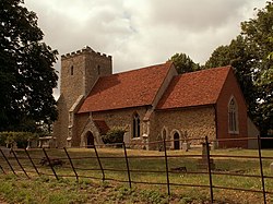
 St Lawrence's church, Asheldham | |
| Location | |
| Grid reference: | TL969011 |
| Location: | 51°40’27"N, 0°50’47"E |
| Data | |
| Population: | 142 (2011[1]) |
| Post town: | Southminster |
| Postcode: | CM0 |
| Dialling code: | 01621 |
| Local Government | |
| Council: | Maldon |
| Parliamentary constituency: |
Maldon & East Chelmsford |
Asheldham is a village and parish in the Dengie hundred of Essex. It is located about nine miles south-east of Maldon and is 16 miles east-south-east from the county town of Chelmsford. The village shares a joint parish council with Dengie, entitled Asheldham and Dengie.[2]
It is on the Dengie peninsula, and is about 12 miles by road from Maldon. According to the 2001 census it had a population of 150, reducing to 142 at the Census 2011.[1]
A Ham class minesweeper launched in September 1953 was named after the hamlet.
References
- ↑ 1.0 1.1 "Civil Parish 2011". http://www.neighbourhood.statistics.gov.uk/dissemination/LeadKeyFigures.do?a=7&b=11120123&c=CM0+7DU&d=16&e=62&g=6425483&i=1001x1003x1032x1004&m=0&r=0&s=1442946117167&enc=1. Retrieved 22 September 2015.
- ↑ "Parish Council Contacts". www.maldon.gov.uk. Archived from the original on 2007-09-28. https://web.archive.org/web/20070928221056/http://www.maldon.gov.uk/LocalDemocracy/ParishCouncils/clerks.htm. Retrieved 2007-01-24.
Outside links
| ("Wikimedia Commons" has material about Asheldham) |
- Information and photographs of Asheldham village
- The history of Asheldham
- Asheldham in the Domesday Book