| Arnold
|
| Nottinghamshire
|
St Mary's Church, Arnold
|
| Location
|
| Grid reference:
|
SK590450
|
| Location:
|
53°0’7"N, 1°7’48"W
|
| Data
|
| Population:
|
37,768 (2011)
|
| Post town:
|
Nottingham
|
| Postcode:
|
NG5
|
| Dialling code:
|
0115
|
| Local Government
|
| Council:
|
Gedling
|
Parliamentary
constituency:
|
Gedling
|
Arnold is a Nottinghamshire market town at the north-eastern edge of the urban spread of Nottingham, such that it is becoming a suburb of the city.
Since 1968 Arnold has had a market, and the town used to have numerous factories associated with the hosiery industry. At the time of the 2011 Census, Arnold had a population of 37,768.
Name
Arnold was referred to as Ernehale in the Domesday Book of 1068, which seems to be form an Old English original Earnan halh meaning ‘place of eagles’ or ‘the valley of eagles’.[1][2]
‘A History of Arnold’ (1913) by Rev Rupert W King and Rev James Russell explains the etymology of Arnold’s name thus:
'Heron-hald', meaning the corner of the forest where Herons (large birds) live. Which becomes over the centuries since 500 A.D. by 'lazy' pronunciation, Eron-ald, thence Ern-old and Arn-old.
Arnold is not a place of eagles nor ever has been: there are no cliffs nor rocky outcrops here, albeit that the fish-eating white-tailed eagle might once have caught fish in the River Trent four miles off and maybe roosted in the forest.
The latter element of the name, the Old English halh, describes Arnold's position surrounded by a circular ridge from the northwest around to the southeast and raised ground to the west. This bowl-like topography may be the 'halh' or 'Haugh'.
Churches
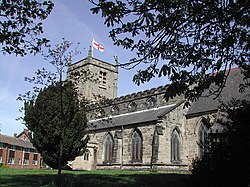
The parish church is St Mary's, which is believed to date from 1176.[3] It stands on Church Lane and is a Grade II* listed building.[4]
- Church of England:
- St Mary's Church, Arnold
- St Paul's Church, Daybrook (built in 1895 and consecrated in 1896)
- Baptist:
- Cross Street Baptist Church, Arnold, opened in 1909
- Daybrook Baptist Church, built in 1912
- Independent / evangelical: The King’s Church, on Shirley Drive
- Methodist: Arnold Methodist
- Roman Catholic: Church of the Good Shepherd, built in 1964
History
Framework knitting industry
Arnold was a centre of the framework knitting industry in the 19th century. It was the site of the first framebreaking incidents of the Luddite riots, on 11 March 1811, when 63 frames were smashed.[5][6] The Luddite riots were a workers’ response to decreasing pay, standard of living and conditions of employment in the industry as a result of changing fashions decreasing demand for their style of hosiery.
Market
1968 saw the opening of Arnold Market in the town centre. Market days are on Tuesdays, Fridays and Saturdays, with a flea market being held on Wednesdays.[7] Being a private market, it is not run by Gedling Borough Council.[8]
Railway
Arnold once had a railway station known as ‘Daybrook and Arnold’ or simply ‘Daybrook railway station’. It was closed along with the rest of the line on 4 April 1960. The station was located on Mansfield Road (the A60) on what is now a retail park. There is still evidence of the line in the form of remnants of the embankments on Arnot Hill Park (just behind the B&Q). The Line was the Great Northern Main Line later nicknamed ‘the back route’, with trains to Gedling and Netherfield with the terminus being Nottingham Victoria. Just after those embankments a later built railway—the Nottingham Suburban Railway—joined it and ran over Thackerays Lane on a bridge on its way to Woodthorpe Park and beyond.[9]
Recreation
The town has a King George V Playing Field, known as King George V Park. This was a late addition to the King George's Fields: in 1950 the Home Brewery Company Ltd gave the land for the King George V Park, which is thus dedicated as a permanent memorial to King George V and guaranteed for free public access in perpetuity for recreation. In 2005 the Charity Commission investigated restricted public access to the park which resulted in free public access (and moved Arnold Town FC off the field).
Pictures
| 1877 boundary mark, marking the Nottingham–Arnold civil boundary [10]
|
| Front Street, Christmas Eve
|
| 34 High Street, Arnold (the town's oldest house [11]
|
| The Lord Nelson, now a café
|
| The Major Oak, on the junction of Rolleston Drive and Brook Street
|
| The junction of Nottingham Road with Mansfield Road
|
| Oxclose Lane Police Station
|
| Daybrook Almshouses on Mansfield Road
|
|
Outside links
| |
("Wikimedia Commons" has material
about Arnold)
|
References


.jpg)

