Difference between revisions of "Ansty, Dorset"
From Wikishire
(Created page with "{{Infobox town |name=Ansty |county=Dorset |picture=Higher Ansty, thatched cottage - geograph.org.uk - 500362.jpg |picture caption=Thatched cottage in Higher Ansty |os grid ref...") |
(No difference)
|
Latest revision as of 22:21, 12 May 2020
| Ansty | |
| Dorset | |
|---|---|
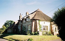
 Thatched cottage in Higher Ansty | |
| Location | |
| Grid reference: | ST769036 |
| Location: | 50°49’54"N, 2°19’44"W |
| Data | |
| Postcode: | DT2 |
| Local Government | |
| Council: | Dorset |
Ansty is a village in Dorset, north of Cheselbourne and west of Milton Abbas. It consists of the settlements of Higher Ansty, Lower Ansty, Pleck (also known as Little Ansty) and Ansty Cross. The Hall & Woodhouse brewing company founded a brewery in the village in 1777, and brewing continued here until the 1940s. The village hall used to be a brewery building, and the old malthouse became Malthouse Cottages.[1]
Outside links
| ("Wikimedia Commons" has material about Ansty, Dorset) |
References
- ↑ Clive Hannay (June 2012). "Clive Hannay paints Ansty". Dorset Life Magazine. http://www.dorsetlife.co.uk/2012/06/clive-hannay-paints-ansty/. Retrieved 7 March 2014.