Difference between revisions of "Almer"
From Wikishire
(Created page with "{{Infobox town |name=Almer |county=Dorset |picture=The Parish Church of St Mary, Almer - geograph.org.uk - 456894.jpg |picture caption=St Mary, Almer |os grid ref=SY913988 |la...") |
(No difference)
|
Latest revision as of 23:00, 8 May 2020
| Almer | |
| Dorset | |
|---|---|
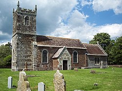
 St Mary, Almer | |
| Location | |
| Grid reference: | SY913988 |
| Location: | 50°47’23"N, 2°7’29"W |
| Data | |
| Postcode: | DT11 |
| Local Government | |
| Council: | Dorset |
Almer is a tiny village in Dorset on the A31 road near Winterborne Zelston, Huish Manor, Sturminster Marshall and opposite the Drax estate.
The main features of the village are Almer Manor, Almer Parish church and the old school house. The school was co-educational; it opened in 1925 and closed in 1964. The Almer School Honours tablet is now kept in Winterborne Zelston village hall. The seven residential properties in Almer are owned and let by the Charborough (Drax) Estate.
Church
Almer's Parish Church is the Church of St Mary, Almer. It is Grade I listed.[1]
Outside links
| ("Wikimedia Commons" has material about Almer) |
References
- ↑ National Heritage List 1154550: Church of St Mary, Almer