Allington, Dorset
| Allington | |
| Dorset | |
|---|---|
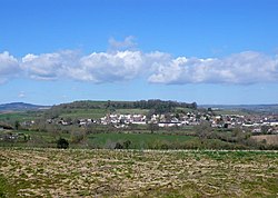
 Allington and Allington Hill from the south | |
| Location | |
| Grid reference: | SY459933 |
| Location: | 50°44’12"N, 2°45’53"W |
| Data | |
| Population: | 766 (2011 [1]) |
| Post town: | Bridport |
| Postcode: | DT6 |
| Dialling code: | 01308 |
| Local Government | |
| Council: | Dorset |
| Website: | http://www.allington.co.uk/ |
Allington is a village and parish in Dorset, a mile north-west from the town of Bridport, with which it is physically contiguous; much of Allington lies within Bridport parish. In the 2011 census Allington civil parish had 371 dwellings,[2] 339 households and a population of 766.[1]
Allington Hill rises to 292 ft above the village; it is managed by the Woodland Trust.[3] The hill is characteristic of the Upper Greensand hills and ridges found in the Marshwood and Powerstock Vales National Character Area.
In 1086 in the Domesday Book Allington was recorded as Adelingtone;[4] it had 21 households, 3 ploughlands, 10 acres of meadow and one mill. It was recorded in Goderthorn Hundred and the lord and tenant-in-chief was Turstin son of Rolf.[5]
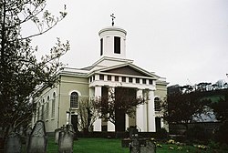
The parish church at North Allington, dedicated to St Swithun, was designed by Charles Wallis of Dorchester and built in 1826-27, and is a Grade II* listed building. It is in classical style, and is unusual for the survival of a high proportion of the original internal fittings, including the pews, gallery, a pulpit (of two originally present) and glazing.[6]
References
- ↑ 1.0 1.1 "Area: Allington (Parish). Key Figures for 2011 Census: Key Statistics". Neighbourhood Statistics. Office for National Statistics. http://www.neighbourhood.statistics.gov.uk/dissemination/LeadKeyFigures.do?a=7&b=11119942&c=allington&d=16&e=62&g=6418511&i=1001x1003x1032x1004&m=0&r=1&s=1367533124873&enc=1. Retrieved 2 May 2013.
- ↑ "Area: Allington (Parish). Dwellings, Household Spaces and Accommodation Type, 2011 (KS401EW)". Neighbourhood Statistics. Office for National Statistics. http://www.neighbourhood.statistics.gov.uk/dissemination/LeadTableView.do?a=7&b=11119942&c=allington&d=16&e=62&g=6418511&i=1001x1003x1032x1004&m=0&r=1&s=1423559152696&enc=1&dsFamilyId=2481. Retrieved 10 February 2015.
- ↑ "Allington Hill & Cooper's Wood". Woodland Trust. http://www.woodlandtrust.org.uk/visiting-woods/wood/4207/allington-hill-coopers-wood/. Retrieved 29 March 2015.
- ↑ "Dorset A-G". The Domesday Book Online. domesdaybook.co.uk. http://www.domesdaybook.co.uk/dorset1.html. Retrieved 29 March 2015.
- ↑ "Place: Allington". Open Domesday. domesdaymap.co.uk. http://domesdaymap.co.uk/place/SY4693/allington/. Retrieved 29 March 2015.
- ↑ National Heritage List 1216300: Church of St Swithun
| ("Wikimedia Commons" has material about Allington, Dorset) |
