Aldfield
| Aldfield | |
| Yorkshire West Riding | |
|---|---|
 Aldfield | |
| Location | |
| Grid reference: | SE263693 |
| Location: | 54°7’12"N, 1°35’53"W |
| Data | |
| Post town: | RIPON |
| Postcode: | HG4 |
| Local Government | |
| Council: | Harrogate |
| Parliamentary constituency: |
Skipton and Ripon |
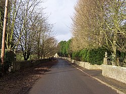
Aldfield is a village in the West Riding of Yorkshire, about three miles west of Ripon. It is the closest village to Fountains Abbey: the village became part of the abbey estate in 1356.[1]
The village is in the Claro Wapentake of the West Riding of Yorkshire.
The population of the parish was estimated at 80 in 2013. It is not separately counted in the census.
Aldfield is listed in the Domesday Book of 1086.[2]
Sulphurous mineral springs were discovered near Aldfield in around 1698 leading to the establishment of Aldfield Spa. Lord de Grey, on whose land the spring was, adapted an adjacent cottage so that the water could be used there for the treatment of various ailments. It closed in the 1930s but the ruined buildings are still visible.[3][4][5]
Outside links
| ("Wikimedia Commons" has material about Aldfield) |
- Aldfield in the Domesday Book
References
- ↑ Wilkinson, George (11 April 2009). "Fountains Abbey". York Press. http://www.yorkpress.co.uk/lifestyle/countrywalks/4284310.display/.
- ↑ Aldfield in the Domesday Book
- ↑ Samuel Lewis, ed (1848). A Topographical Dictionary of England. London. pp. 26–31. http://www.british-history.ac.uk/topographical-dict/england/pp26-31. Retrieved 2 January 2018.
- ↑ Mark Reid. "The Aislabie Walk". The Woodland Trust. https://www.woodlandtrust.org.uk/mediafile/100048013/aislabie-walk-leaflet.pdf. Retrieved 2 January 2018.
- ↑ A. B. Granville (1841). The Spas of England and Principal Sea-bathing Places: Northern Spas. London: Henry Colburn. pp. 105–7. https://archive.org/details/spasenglandandp02grangoog. Retrieved 2 January 2018.