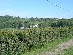
Abergele
| Abergele | |
| Denbighshire | |
|---|---|

| |
| Location | |
| Grid reference: | SH945775 |
| Location: | 53°16’48"N, 3°34’48"W |
| Data | |
| Population: | 10,016 (2001) |
| Post town: | Abergele |
| Postcode: | LL22 |
| Dialling code: | 01745 |
| Local Government | |
| Council: | Conwy |
| Parliamentary constituency: |
Clwyd West |
Abergele is a town on the north coast of Denbighshire, of ancient roots, originating in an old Roman trading town.
Today's town stands between the holiday resorts of Colwyn Bay and Rhyl. Its northern suburb of Pensarn is on the Irish Sea coast and has a popular beach, though overlooked by casual visitors drawn by the lights of Rhyl and Colwyn Bay
The town is known for Gwrych Castle. It is surrounded by wooded hillsides, which contain caves with rare lesser horseshoe bat. The highest hill is Moelfre Isaf (1,038 ft) to the south of the town. There are also outstanding views from Cefn-yr-Ogof (669 ft), Tower Hill (587 ft) and Tan-y-Gopa.
Abergele's anme is Welsh for "Mouth of the Gele", the river which flows through the town. Gele itself is a dialectal form of gelau, which means spear, which may describe the action of the river cutting through the land or because its waters flash brightly.
Church
The parish church, St Michael's was built on the site of a 'clas' or early monastery.
A curious, undated inscription can be found on a tombstone in the churchyard. It states "Here lieth in St Michael's churchyard a man who had his dwelling three miles to the north". As the sea is little more than half a mile away at this point, this suggests that the sea has made some considerable advance over the centuries.[1]
Outside the church is a penitential stone where before the Reformation sinners had to do penance by standing, dressed in white, by the stone and beseech the congregation for mercy as they entered and left the church.
The churchyard also holds a mass grave dug for the victims of the Abergele Train Disaster in 1868, when runaway freight trucks laden with paraffin rolled into a passenger train at Abergele and exploded. In the fire, 32 passengers and the fireman were killed at once, and lie buried together at Abergele.
History
A settlement of some kind continued to exist at Abergele into the thirteenth century; King Edward I is known to have briefly stayed there in December 1294 during his campaign to suppress the revolt of Madog ap Llywelyn.
Sites of historical interest include two Iron Age hillforts; Castell Cawr at Tan-y-Gopa and Fort Dinorben (now virtually disappeared owing to limestone quarrying) at St George. On Gallt y Felin Wynt, a hill above the town popularly known as Tower Hill is a 17th-century watchtower, partially restored in 1930. Another Iron Age fort is found at Pen-y-Corddyn Mawr hill above Rhyd-y-foel. Another watchtower, the Lady Emilys Tower, stands near Cefn-yr-Ogof.
Gwrych Castle was built between 1819-1825 at the behest of Lloyd Hesketh Bamford-Hesketh. From 1894 until 1946 it was the residence of the Dundonald family.[2] Gwrych Castle's present owner, Californian businessman Nick Tavaglione, who bought the landmark in December 1989 put Gwrych up for auction on 2 June 2006, but it failed to sell. The condition of the property is being monitored by the Gwrych Castle Preservation Trust.[3] It is undergoing renovation.
A sanatorium was built just outside Abergele in 1910, bought in 1914 by the City of Manchester Corporation, who later built a children's sanatorium on the same site. In 1948 the new National Health Service took the sanatorium from the City Council and later closed it when the introduction of antibiotics made the building redundant.
Genetic puzzle
Recent genetic studies on the y-chromosomes of men in Abergele, carried out as part of the Genetic history of Europe project,[4] have revealed that there is a substantial percentage of E1b1b1a2 haplogroup in Abergele. Membership of this haplogroup was found to average at 38.97% in male y-chromosomes in Abergele.
This particular genetic marker is found at its highest concentrations in the Balkans, at up to approximately 40% in areas, but at less than 5% in Northern Europe. A suggested reason for the high levels of E1b1b in Abergele is the heavy Roman Army presence in Abergele nearly 2,000 years ago. Other places in Britain with above-average levels of genetic marker E-V13 been towns known to have had a heavy Roman presence.[5]
References
- ↑ Black, Adam and Charles (1857). Black's Picturesque Guide to North Wales. p. 30.
- ↑ "A brief history of Gwrych Castle". Gwrych Castle Preservation Trust. http://www.gwrychtrust.co.uk/html/brief_castle_history.html. Retrieved 14 March 2009.
- ↑ "What is the Castle Trust?". Gwrych Castle Preservation Trust. http://www.gwrychtrust.co.uk/html/about_us.html. Retrieved 14 March 2009.
- ↑ "Y Chromosome Evidence for Anglo-Saxon Mass Migration". 25 January 2002. http://mbe.oxfordjournals.org/cgi/reprint/19/7/1008.pdf. Retrieved 5 November 2006.
- ↑ Bird, Steven (2007). Haplogroup E3b1a2 as a Possible Indicator of Settlement in Roman Britain by Soldiers of Balkan Origin. 3. http://www.jogg.info/32/bird.htm. Retrieved 10 November 2008.
Outside links
- Abergele Town Council
- Abergele in Shorts
- Gwrych Castle Preservation Trust official site
- Gwrych Castle website: www.gwrych.co.uk
- Gwrych Castle website: www.gwrych.org.uk
- Photos of Gwrych Castle
- Wales DNA Project
- Rhyl, Prestatyn and Abergle Journal newspaper
- Geograph: photos of Abergele and surrounding area
- Manchester City Council memories of Abergele Sanatorium