File:Robertson Island location in Graham Land, BAT.svg
From Wikishire

Size of this preview: 462 × 599 pixels. Other resolution: 185 × 240 pixels.
Original file (SVG file, nominally 1,282 × 1,662 pixels, file size: 3.99 MB)
Summary
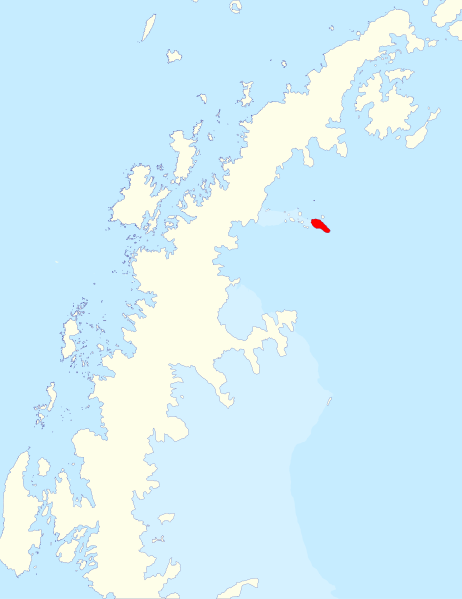
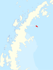
| Description | Locator map of Robertson Island off Graham Land, in the British Antarctic Territory |
| Date | |
| Source | Data from British Antarctic Survey Geodata Portal - Antarctic Digital Database |
| Author |
British Antarctic Survey
|
| Permission (Reusing this file) |
This file is licensed under the Creative Commons Attribution 4.0 International license. Attribution: Antarctic Digital Database
|
File history
Click on a date/time to view the file as it appeared at that time.
| Date/Time | Thumbnail | Dimensions | User | Comment | |
|---|---|---|---|---|---|
| current | 17:33, 5 January 2024 | | 1,282 × 1,662 (3.99 MB) | Hogweard | == {{int:filedesc}} == {{Information |Description=Locator map of Robertson Island off Graham Land, in the British Antarctic Territory |source={{BAS data|source}} |author={{BAS data|author}} *Derivative work: {{u|Hogweard}} |permission={{BAS data}} |date=2024-01-05 |other_versions= }} Category:Maps of islands off Graham Land Category:Maps of the British Antarctic Territory |
File usage
The following file is a duplicate of this file (more details):
- File:Robertson Island location in Graham Land, BAT.svg from a shared repository
The following page links to this file: