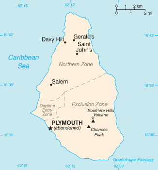
File:Montserrat-CIA WFB Map.png
From Wikishire
No higher resolution available.
Montserrat-CIA_WFB_Map.png (326 × 349 pixels, file size: 7 KB, MIME type: image/png)
This image is in the public domain because it contains materials that originally came from the United States Central Intelligence Agency's World Factbook.
|
 |

|
This file has been superseded by Montserrat map - CIA World Factbook 2021.jpg. It is recommended to use the other file. Please note that deleting superseded images requires consent.
|

|
File history
Click on a date/time to view the file as it appeared at that time.
| Date/Time | Thumbnail | Dimensions | User | Comment | |
|---|---|---|---|---|---|
| current | 13:45, 25 October 2021 | | 326 × 349 (7 KB) | Lojwe | Cropped 1 % horizontally, 1 % vertically using CropTool with precise mode. |
File usage
The following file is a duplicate of this file (more details):
- File:Montserrat-CIA WFB Map.png from a shared repository
The following page links to this file: