File:Dunloe Ogham Stones, Beaufort (506431) (27478034901).jpg
From Wikishire

Size of this preview: 400 × 600 pixels. Other resolution: 160 × 240 pixels.
Original file (3,198 × 4,797 pixels, file size: 6.66 MB, MIME type: image/jpeg)
_(27478034901).jpg)
Summary
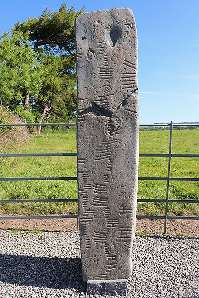
| Description | Dunloe Ogham Stone CIIC 241, Beaufort, Co. Kerry, Ireland |
| Date | |
| Source | Dunloe Ogham Stones, Beaufort (506431) |
| Author | Robert Linsdell from St. Andrews, Canada |
| Camera location | | View this and other nearby images on: OpenStreetMap |
|---|
_(27478034901).jpg¶ms=052.060394_N_-009.634794_E_globe:Earth_type:camera_source:Flickr_&language=en)
Licensing
This file is licensed under the Creative Commons Attribution 2.0 Generic license.
- You are free:
- to share – to copy, distribute and transmit the work
- to remix – to adapt the work
- Under the following conditions:
- attribution – You must give appropriate credit, provide a link to the license, and indicate if changes were made. You may do so in any reasonable manner, but not in any way that suggests the licensor endorses you or your use.
| This image was originally posted to Flickr by Bob Linsdell at https://flickr.com/photos/92487715@N03/27478034901 (archive). It was reviewed on 6 May 2018 by FlickreviewR 2 and was confirmed to be licensed under the terms of the cc-by-2.0. |
File history
Click on a date/time to view the file as it appeared at that time.
| Date/Time | Thumbnail | Dimensions | User | Comment | |
|---|---|---|---|---|---|
| current | 18:55, 6 May 2018 | | 3,198 × 4,797 (6.66 MB) | OceanAtoll | Transferred from Flickr via #flickr2commons |
File usage
The following file is a duplicate of this file (more details):
_(27478034901).jpg)
- File:Dunloe Ogham Stones, Beaufort (506431) (27478034901).jpg from a shared repository
The following page links to this file:
_(27478034901).jpg)
_(27478034901).jpg)
_(27478034901).jpg&action=edit&redlink=1)
_(27478034901).jpg)
_(27478034901).jpg&action=info)