File:Carrick Roads Panorama.jpg
From Wikishire

Size of this preview: 800 × 176 pixels. Other resolution: 320 × 70 pixels.
Original file (4,632 × 1,019 pixels, file size: 2.45 MB, MIME type: image/jpeg)
Summary
| Camera location | | View this and other nearby images on: OpenStreetMap |
|---|
| Description |
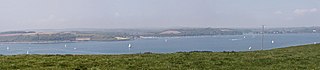
Deutsch: Carrick Roads zwischen Falmouth und Feock, von Roseland aus gesehen, links Mylor, rechts Feock English: Carrick Roads between Falmouth and Feock, as seen from Roseland, left hand Mylor, right hand Feock |
| Date | |
| Source | Eva K. / Eva K. |
| Author | Eva K. / Eva K. |
Licensing
I, the copyright holder of this work, hereby publish it under the following licenses:
English: I, Eva Kröcher (Eva K.) am the creator of this work and I hereby publish it under the licences detailed below.
You may use this work free of charge under two conditions: Naming the image's author and inheritance of the chosen license. If you want to learn more details about the usage of this work, please visit my userpage. Deutsch: Ich, Eva Kröcher (Eva K.) bin die Autorin dieses Bildwerkes, und ich veröffentliche es hiermit unter den unten beschriebenen Lizenzen.
Sie dürfen dieses Bild unter folgenden Bedingungen kostenlos nutzen: Namensangabe des Bildautors und Weitervererbung der gewählten Lizenz. Bitte schauen Sie auf meine Benutzerseite, wenn Sie Einzelheiten über die Nutzung dieses Bildwerkes erfahren wollen. | |||||||||
| |||||||||
| |||||||||
|

|
Permission is granted to copy, distribute and/or modify this document under the terms of the GNU Free Documentation License, Version 1.2 or any later version published by the Free Software Foundation; with no Invariant Sections, no Front-Cover Texts, and no Back-Cover Texts. A copy of the license is included in the section entitled GNU Free Documentation License. |
This file is licensed under the Creative Commons Attribution-Share Alike 2.5 Generic, 2.0 Generic and 1.0 Generic license.
- You are free:
- to share – to copy, distribute and transmit the work
- to remix – to adapt the work
- Under the following conditions:
- attribution – You must give appropriate credit, provide a link to the license, and indicate if changes were made. You may do so in any reasonable manner, but not in any way that suggests the licensor endorses you or your use.
- share alike – If you remix, transform, or build upon the material, you must distribute your contributions under the same or compatible license as the original.
You may select the license of your choice.
File history
Click on a date/time to view the file as it appeared at that time.
| Date/Time | Thumbnail | Dimensions | User | Comment | |
|---|---|---|---|---|---|
| current | 14:58, 27 July 2009 | 4,632 × 1,019 (2.45 MB) | EvaK | new version |
File usage
The following file is a duplicate of this file (more details):
- File:Carrick Roads Panorama.jpg from a shared repository
The following page links to this file: