File:Anvers Island, Palmer Archipelago, BAT.svg
From Wikishire

Size of this preview: 522 × 514 pixels. Other resolution: 244 × 240 pixels.
Original file (SVG file, nominally 522 × 514 pixels, file size: 3.53 MB)
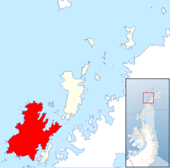
Summary
| Description | Locator map of Anvers Island in the Palmer Archipelago in the British Antarctic Territory |
| Date | |
| Source | Palmer Archipelago, British Antarctic Territory.svg |
| Author | Hogweard |
| Permission (Reusing this file) |
This file is licensed under the Creative Commons Attribution 1.0 Generic license. Attribution: Antarctic Digital Database
|
File history
Click on a date/time to view the file as it appeared at that time.
| Date/Time | Thumbnail | Dimensions | User | Comment | |
|---|---|---|---|---|---|
| current | 22:36, 6 December 2022 | | 522 × 514 (3.53 MB) | Hogweard | == {{int:filedesc}} == {{Information |Description=Locator map of Anvers Island in the Palmer Archipelago in the British Antarctic Territory |Source={{f|Palmer Archipelago, British Antarctic Territory.svg}} |Date=2022-12-06 |Author={{u|Hogweard}} |permission={{Cc-by-1.0|Antarctic Digital Database}} *Licence: [https://data.bas.ac.uk/items/e46be5bc-ef8e-4fd5-967b-92863fbe2835/#item-details-licence Antarctic Digital Database] |other_versions= }} Category:Maps of the Palmer Archipelago [[Categ... |
File usage
The following file is a duplicate of this file (more details):
- File:Anvers Island, Palmer Archipelago, BAT.svg from a shared repository
The following page links to this file: