File:2019-07-31-Lough Hyne-0828.jpg

Summary
| Description |
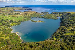
Deutsch: Lough Hyne, Drohnenaufnahme aus 100m Höhe über Grund vom Gipfel des Knockomagh
English: Lough Hyne, seen from a drone 100m above Knockomagh
Español: Lough Hyne, visto desde un dron a 100 metros por encima de Knockomagh, condado de Cork, Irlanda.
|
| Date | Taken on 31 July 2019, 16:57:45 |
| Source | Self-photographed |
| Author | Superbass |
| Permission (Reusing this file) |
I have published this image as author under the Creative-Commons-Licence CC-by-SA-4.0.. This means that free usage outside of Wikimedia projects under the following terms of licence is possible:
To generate a licence text and attribution of the author you're welcome to use the Licence Generator: I would be happy to receive a specimen copy or the URL of the website where the image is used. Please write an email to sesams06.hadron@icloud.com, if you
|
| Camera location | | View this and other nearby images on: OpenStreetMap |
|---|
Assessment
|
This image was selected as picture of the day on Wikimedia Commons for 13 October 2020. It was captioned as follows: English: Lough Hyne, seen from a drone 100m above Knockomagh, County Cork, Ireland. Other languages:
Deutsch: Lough Hyne, Drohnenaufnahme aus 100m Höhe über Grund vom Gipfel des Knockomagh. English: Lough Hyne, seen from a drone 100m above Knockomagh, County Cork, Ireland. Español: Lough Hyne visto desde un dron a 100 metros por encima de Knockomagh, condado de Cork, República de Irlanda. Português: Lough Hyne visto de um drone a 100 metros acima de Knockomagh, condado de Cork, República da Irlanda Македонски: Приморското езеро Лох Хајн во грофовијата Корк, Ирска. |

|
This image has been assessed under the valued image criteria and is considered the most valued image on Commons within the scope: Lough Hyne, aerial view. You can see its nomination here. |
.JPG) |
This picture has been taken by members of the community project „Lokal K - Drohnenfotografie“. |
Licensing
- You are free:
- to share – to copy, distribute and transmit the work
- to remix – to adapt the work
- Under the following conditions:
- attribution – You must give appropriate credit, provide a link to the license, and indicate if changes were made. You may do so in any reasonable manner, but not in any way that suggests the licensor endorses you or your use.
- share alike – If you remix, transform, or build upon the material, you must distribute your contributions under the same or compatible license as the original.
| Annotations | This image is annotated: View the annotations at Commons |
File history
Click on a date/time to view the file as it appeared at that time.
| Date/Time | Thumbnail | Dimensions | User | Comment | |
|---|---|---|---|---|---|
| current | 21:15, 4 August 2019 | | 5,464 × 3,640 (14.14 MB) | Superbass | Uploaded with LrMediaWiki 0.8.0, LR 8.3.1 Win |
File usage
The following file is a duplicate of this file (more details):
- File:2019-07-31-Lough Hyne-0828.jpg from a shared repository
The following page links to this file: