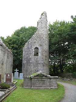
Dysert O'Dea Monastery
| Dysert O'Dea Monastery | |
|
County Clare | |
|---|---|
 Dysert O'Dea round tower | |
| Location | |
| Grid reference: | R28178477 |
| Location: | 52°54’33"N, 9°4’6"W |
| History | |
| Founder: | Tola of Clonard |
| Information | |
| Condition: | Ruins |
Dysert O'Dea Monastery stands in ruin near the village of Corofin in County Clare, Within the site today stands Dysert O'Dea Church.
This was the site of an early Christian monastery which was reportedly founded by Tola of Clonard in the 8th century. Most of the present structures are from the 12th century.
Architecture
The remains of the monastic site include "St Tola's Church", a round tower, "St Tola's Well" and "St. Tola's Cross".[1]
The church of today stands on the site of the original monastery, reportedly founded by Tola of Clonard in the 8th century. The ruined Romanesque structure visible today mainly dates to the 12th century and is over 100 feet long. The lancet windows in the east gable were additions from the early 13th century. The stone arch, showing twelve human and seven animal heads, also dates to the 13th century. Inside the church is the grave of Joan O'Dea, wife of the last clan chieftain, Michael O'Dea (dating to 1684).[1][2]
The late 11th century round tower was converted into a fortification in the 16th century. It was severely damaged by artillery fire by Cromwellian forces in 1651. Of an estimated original height of around 100 feet, only about a third still remains. An old bronze bell discovered in 1790 was taken to Corofin and sold to pay for the current church bell. In the 1850s, Edward Synge, the local landlord, made repairs to the tower.[1]
St Tola's Well is a pre-Christian well that was the site of an annual pilgrimage on 30 March. In the 1860s the landlord had the well paved over but it was reopened in 1986.[1]
A High Cross, the so-called "St Tola's Cross", is located in a field to the east of the church. It dates to the 12th century. The upper part shows the crucifixion, while on the shaft is the figure of a bishop, with the back and sides showing Irish interlacing work. The cross was knocked over by the Cromwellian soldiers but repaired by Michael O'Dea in 1683. Since he used stones from the church to set up the pedestal, the church building must have fallen into disuse by then. The Synge family again restored the cross in 1871. In 1960, the cross was temporarily dismantled and shipped to Barcelona for an exhibition on Irish art.[1]
Nearby
This monastic site is part of the Dysert O'Dea Archaeological Trail. There are many more historical sites in the immediate vicinity including O'Dea Castle, two ring forts, the remains of a fulacht fiadh, and the ruins of a stone Victorian house dating from 1861.[1]
"Synge's Lodge" is a ruined guest house, originally built in the Georgian style not far from the church ruins. The Synge coat of arms with the motto "Caelesta canimes" remains over the door. The Synge's local agent lived in nearby "Mollaneen House", built c. 1780. This had a walled garden and orchard.[1]
The Battle of Dysert O'Dea of 1318 took place near the monastic site.
Today
The church, round tower and high cross are today designated as a National Monument.
Pictures
-
Doorway of St Tola's Church
-
The faces found on the outer arch of the doorway
-
St Tola's Cross
-
Details of St Tola's Cross
-
Victorian ruins of Synge's Lodge
See also
Outside links
- Curry, Eugene: 'The Burren: Dysert O'Dea Church' (1839) via Clare Library
References
- ↑ 1.0 1.1 1.2 1.3 1.4 1.5 1.6 Cronin, Richard: 'Dysert O'Dea - A history trail' - Guide and Map (Dysert Development Association, 1989)
- ↑ "Clare County Library: Churches with Round Towers in Northern Clare by Thomas Johnson Westropp". http://www.clarelibrary.ie/eolas/coclare/archaeology/churches/dysert_odea.htm. Retrieved 13 January 2014.
- Ua Cróinín, Risteárd (Richard Cronin): 'O'Dea: Ua Deághaidh: The Story of a Rebel Clan' (Ballinakella Press, 1992) ISBN 0-946538-07-7


