Tadmarton
| Tadmarton | |
| Oxfordshire | |
|---|---|
 St Nicholas, Tadmarton | |
| Location | |
| Grid reference: | SP392378 |
| Location: | 52°2’16"N, 1°25’45"W |
| Data | |
| Population: | 541 (2011) |
| Post town: | Banbury |
| Postcode: | OX15 |
| Dialling code: | 01295 |
| Local Government | |
| Council: | Cherwell |
| Parliamentary constituency: |
Banbury |
| Website: | tadmartonvillage.co.uk |
Tadmarton is a village in Oxfordshire about four miles west of Banbury. The 2011 Census recorded the parish's population as 541.
The village has one public house, the Lampet Arms.[1]
History and heritage
The manor house has a 15th-century barn, believed to have been built for Abingdon Abbey.[2]
Parish church
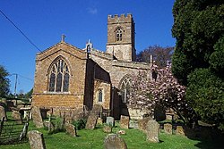
The parish church, St Nicholas is early Norman. The building was enlarged and the bell tower added in the 13th century.[3] The church is a Grade I listed building.[4]
The tower has a ring of six bells.[5]
Outside links
| ("Wikimedia Commons" has material about Tadmarton) |
References
- ↑ The Lampet Arms
- ↑ Lobel & Crossley 1969, pp. 150-159.
- ↑ Lobel & Crossley 1969, pp. 150–159.
- ↑ National Heritage List 1369852: Church of St Nicholas, Main Street (Grade I listing)
- ↑ Oxford Diocesan Guild of Church Bell Ringers, Banbury Branch
- A History of the County of Oxford - Volume 9 pp 150-159: Parishes: Tadmarton (Victoria County History)
- Nikolaus Pevsner: The Buildings of England: Oxfordshire, 1974 Penguin Books ISBN 978-0-300-09639-2
