Seacroft
| Seacroft | |
| Yorkshire West Riding | |
|---|---|
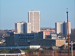
 Seacroft from Fearnville | |
| Location | |
| Grid reference: | SE362365 |
| Location: | 53°49’20"N, 1°27’36"W |
| Data | |
| Population: | 14,246 (2011) |
| Post town: | Leeds |
| Postcode: | LS14 |
| Dialling code: | 0113 |
| Local Government | |
| Council: | Leeds |
| Parliamentary constituency: |
Leeds East |
Seacroft is an old village which has become a run-down outer-city suburb or township consisting mainly of council estate housing covering an extensive area of east Leeds in the West Riding of Yorkshire. Seacroft is four miles east of Leeds city centre.
The population of the corresponding Leeds City Ward was recorded as 14,426 at the 2011 census.
Seacroft includes one of the largest council estates in the country and Yorkshire's largest after Bransholme in Kingston upon Hull. Its size is such that Seacroft has often been referred to as a town. The original vision, envisaged by the council, was that it would be a 'Town within the City Limits', and the Seacroft Civic Centre was often referred to as the 'Seacroft Town Centre'.[1]
The Green
Seacroft was at one time a small village between Leeds and York. The village green, known as "The Green" still exists. It has the Cricketers Arms pub on the north side and St James parish church (built 1845, architect T. Hellyer) on the south side. John Wesley preached on The Green, and as a result a Wesleyan Chapel (Methodist Church) was built close by.[2] Seacroft Green has an active residents' association.
-
The Green
-
Houses on The Green
-
The Cricketers Arms, The Green
-
St James's Parish Church (C of E), The Green (1845)
History
Village

Evidence of early habitation was found during construction of the estate in the 1950s. A stone axe dating from the Neolithic age (3500–2100 BC) was found on Kentmere Avenue. In addition, two silver Roman coins were found on The Green in the 1850s.[3]
Seacroft village is recorded in the Domesday Book of 1086.[4]

Seacroft village is the original part of Seacroft, around The Green and Cricketers Arms (pictured above), and is often referred to today. Seacroft Hall was built in the 17th century by the Shiletto family incorporating extensive landscaping and parkland. Despite being a listed building, the hall was demolished in the 1950s. The original entrance lodge still stands on York Road, with Parklands School on South Parkway now occupying the location of the hall. There is one shop in the area that was originally Seacroft Village, a small village off-licence, which has been built since the building of the estate.
Seacroft Grange was built in 1627 for the Tottie family and is also known as Tottie Hall.[5] It is a grade II listed building, along with its service buildings.[6][7] The record says it was rebuilt in 1837, but other sources record the building as original, noting that in 1837 the new tenant John Wilson renamed it to Seacroft Grange and set his coat of arms over the door.[8] The building included a celebrated late 17th century staircase thought to have been brought from Austhorpe Hall.[6] It is now part of Seacroft Grange Care Village.[9]

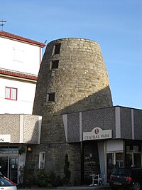
There is an old non-operating windmill, that pre-dates the estate, which has been incorporated into a hotel (now known as the Britannia Hotel Leeds).
Satellite town
The village developed slowly over the centuries and saw very little change until the years after the War. Work on the estate began in the 1950s. Many of the older houses on the estate are more traditional red-brick semis built around the Beechwood area, to the North of the estate. In the 1960s many prefabricated houses and high-rise flats were constructed on the estate. Two main roads were built through the estate, these being North Parkway and South Parkway. North Parkway was built with a dual carriageway, in a similar way as Oak Tree Drive, Coldcotes Drive and Gipton Approach in neighbouring Gipton.
In 1934, Leeds City Council bought 1,000 acres for municipal housing, and after Second World War the majority of houses and blocks of flats were built. The council had planned for Seacroft to be a "satellite town within the city boundary"[10]
In addition to this vision, other areas surrounding Seacroft were built using the same principle. In the 1960s building work in the Swarcliffe and Stanks areas started, and in the 1970s in Whinmoor. However, none of these were as large or ambitious as Seacroft, with the intention that these areas use many of the amenities built along with the Seacroft Estate such as the Civic Centre and Seacroft's secondary schools. As such amenities were kept to a minimum in Swarcliffe and Whinmoor.
Seacroft Civic Centre
The 1960s also saw the construction of the Seacroft Civic Centre, which was at the time a novel way of building an outdoor purpose built town centre. The Civic Centre had a Grandways supermarket and a Woolworths as well as many other smaller shops, banks, pubs and a library. In the 1990s it had become apparent that the condition of the Civic Centre had deteriorated significantly in the 30 years since its construction. Talks were held with Leeds City Council, and Tesco were found as the preferred bidder to rebuild the Seacroft Civic Centre.
Outside links
| ("Wikimedia Commons" has material about Seacroft) |
- Seacroft Village Preservation Society
- BBC News: "The Estate" article about Seacroft
- Queenswiew Flats In Seacroft
- Information on Seacroft from GENUKI
- Yorkshire Evening Post, History of Seacroft
References
- ↑ Leodis photographic archive Seacroft Town Centre, aerial view
- ↑ Leeds Methodist website Seacroft Methodist Church
- ↑ Weldrake, David. "Seacroft History – Seacroft Today". Seacrofttoday.co.uk. http://www.seacrofttoday.co.uk/yourseacroft/Seacroft-History.1794815.jp.
- ↑ Seacroft in the Domesday Book
- ↑ "History of the Village: Photographs (surviving buildings)". Seacroft Village Preservation Society. http://home.freeuk.com/seacroft/sctop.htm.
- ↑ 6.0 6.1 National Heritage List 1255897: The Grange (Grade II listing)
- ↑ National Heritage List 1255898: Coach house and service range to The Grange, (Grade II listing)
- ↑ "Seacroft Grange: Built in the 17th century for the Tottie family – what does the future hold?". Leeds History Journal 13. SSN 1740-5696. https://www.flickr.com/photos/phill_dvsn/3349072537/sizes/o/in/set-72157605819485965/.
- ↑ "Seacroft Grange Care Village". Care Homes Leeds. https://seacroftgrange.com/.
- ↑ "Seacroft, West Yorkshire | England | United Kingdom (UK) | Parish | Village | Community | Seacroft". Any-village.com. http://www.any-village.com/UK/England/West-Yorkshire/Seacroft/home.aspx.


