Llyn y Fan Fawr

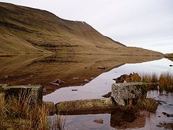
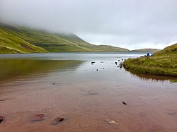
Llyn y Fan Fawr is a natural lake in Brecknockshire, at the foot of Fan Brycheiniog, the highest peak of the Black Mountain range within the Brecon Beacons National Park.[1] Its name is Welsh for 'great lake (near) the peak'.[2] Created as a result of glacial action,[3] it is one of the largest glacial lakes in southern Wales.[4] The lake is roughly rectangular in shape with its long axis oriented roughly north-south.

The surface of Llyn y Fan Fawr lies at about 1,815 feet above sea level.[5][6] Its primary outflow is to the River Tawe.[7] Much of the land around the lake is peaty and thus wet underfoot.
References
- ↑ Andrew Davies; David Whittaker (9 September 2010). Walking on the Brecon Beacons. Cicerone Press Limited. pp. 191–. ISBN 978-1-84965-346-6. https://books.google.com/books?id=f5Qo1yy7xFYC&pg=PA191.
- ↑ Owen, Hywel Wyn; Morgan, Richard (2007). Dictionary of the Place-names of Wales (First ed.). Llandysul: Gomer Press. p. 300. ISBN 9781843239017.
- ↑ Geological Survey of Great Britain (1932). Memoirs. England and Wales: Explanation of Sheet. H.M. Stationery Office. https://books.google.com/books?id=0SEeAQAAMAAJ.
- ↑ Derek Ratcliffe (26 January 2012). A Nature Conservation Review: Volume 1: The Selection of Biological Sites of National Importance to Nature Conservation in Britain. Cambridge University Press. pp. 236–. ISBN 978-0-521-20329-6. https://books.google.com/books?id=YPQaFxH-AZYC&pg=PA236.
- ↑ Hans Luther; Julian Rzóska (1971). Project Aqua: A Source Book of Inland Waters Proposed for Conservation. International Biological Programme. ISBN 978-0-632-08730-3. https://archive.org/details/projectaquasourc0000luth.
- ↑ Ordnance Survey Explorer map OL12 'Brecon Beacons National Park: western area'
- ↑ Bye-gones: Relating to Wales and the Border Counties. Printed at the Caxton works.. 1894. pp. 504–. https://books.google.com/books?id=md4GAAAAYAAJ&pg=PA504.