Queensferry, Flintshire
| Queensferry Welsh: Y Fferi Isaf | |
| Flintshire | |
|---|---|
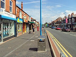
 B5441 at Queensferry | |
| Location | |
| Grid reference: | SJ315685 |
| Location: | 53°12’33"N, 3°1’38"W |
| Data | |
| Post town: | Deeside |
| Postcode: | CH5 |
| Dialling code: | 01244 |
| Local Government | |
| Council: | Flintshire |
| Parliamentary constituency: |
Alyn and Deeside |
Queensferry is a town in eastern Flintshire, lying on the River Dee near the Cheshire border.
Queensferry lies along the B5441 and B5129 roads, and is bypassed by the A494 dual carriageway. It is contiguous with Deeside. Queensferry is considered part of Deeside, which lends its name to many of Queensferry's features, including the Deeside Leisure Centre, a sports and leisure venue which also used to host music concerts.
The town does not have the usual 'cenotaph' style of war memorial, but rather a Memorial Institute. It is a corrugated black and white building which stands near the entrance to Asda from the coast road.