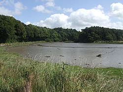
Saleen, County Cork
| Saleen Irish: Sáilín | |
| County Cork | |
|---|---|
 Saleen Creek | |
| Location | |
| Grid reference: | W888679 |
| Location: | 51°51’49"N, 8°9’49"W |
| Data | |
| Population: | 445 (2016) |
| Dialling code: | 021 |
| Local Government | |
| Council: | East Cork |
Saleen is a small village in County Cork, in the east of the county, on the R630 regional road between Midleton and Whitegate.
Saleen Creek opens into Cork Harbour just below the village.
Evidence of ancient settlement in the area includes a megalithic portal tomb in Saleen Creek near Rostellan,[1][2] and ringfort sites in the neighbouring townlands of Scartlea Lower and Jamesbrook.[3]
The village has a Roman Catholic church, the Church of the Mother of God, which was built around 1801. This church is listed on Cork County Council's Record of Protected Structures.[4]
Outside links
References
- ↑ "Rostellan Dolmen". https://www.ringofcork.ie/listings/rostellan-dolmen/. Retrieved 20 December 2020.
- ↑ "Rostellan Portal Tomb". http://www.irishstones.org/place.aspx?p=648. Retrieved 21 December 2020.
- ↑ Archaeological Inventory of County Cork. Volume 2: East and South Cork. Dublin: Govt. Stationery Office. 1994.
- ↑ "Draft Cork County Development Plan - Volume Two - Heritage and Amenity". Cork County Council. 2021. https://www.corkcoco.ie/sites/default/files/2021-04/volume-2-heritage-amenity.pdf. Retrieved 6 July 2021.
- Sáilín / Saleen: Placenames Database of Ireland