Rodley, Gloucestershire
| Rodley | |
| Gloucestershire | |
|---|---|
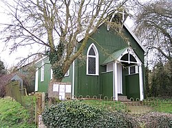
 Rodley Church | |
| Location | |
| Grid reference: | SO745114 |
| Location: | 51°48’4"N, 2°22’11"W |
| Data | |
| Postcode: | GL14 |
| Local Government | |
| Council: | Forest of Dean |
Rodley is a hamlet by Westbury-on-Severn in the west of Gloucestershire. It stands to the south east of Westbury-on-Severn, surrounded on three sides by a loop of the River Severn.
The village has a tin church, known as Rodley Mission Church. This is a prefabricated church constructed in 1908 of galvanised metal over a wooden interior. It is used for occasional services.[1]
There are three Grade II listed buildings in the village:
- Court Farmhouse, 17th century with an early 18th-century extension;[2]
- Dove House, built 1766–77;[3]
- Rodley Court, an 18th-century farmhouse.[4]
Outside links
| ("Wikimedia Commons" has material about Rodley, Gloucestershire) |
- Rodley, Gloucestershire: Vision of Britain
References
- ↑ "Rodley Church". Westbury on Severn Benefice. http://wosb.org.uk/rodley_church.asp. Retrieved 16 September 2012.
- ↑ National Heritage List 1101770: Court Farmhouse (Grade II listing)
- ↑ National Heritage List 1266998: Dove House (Grade II listing)
- ↑ National Heritage List 1186541: Rodley Court (Grade II listing)
