Swyre
| Swyre | |
| Dorset | |
|---|---|
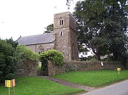
 Parish Church of the Holy Trinity | |
| Location | |
| Grid reference: | SY527882 |
| Location: | 50°41’31"N, 2°40’12"W |
| Data | |
| Population: | 102 (2011) |
| Local Government | |
| Council: | Dorset |
| Parliamentary constituency: |
West Dorset |
Swyre is a small village in south-western Dorset, in a valley beside Chesil Beach six miles south-east of Bridport. The 2011 census noted a parish population of 102.
The village church is dedicated to the Holy Trinity and was largely rebuilt in 1843, though the west tower and chancel arch date from about 1400.[1] The church contains memorial to members of the local gentry, namely the families of Napier, Squibb, Gollop and Russell. The Napiers, originally from Scotland, included Sir Robert Napier, Chief Baron of the Irish Exchequer (died 1615) whose descendants became the Napier Baronets of Middlemarsh.
See also
Outside links
| ("Wikimedia Commons" has material about Swyre) |
References
- ↑ Swyre: An Inventory of the Historical Monuments in Dorset, Volume 1, pages 229-230
