Walham
| Walham | |
| Gloucestershire | |
|---|---|
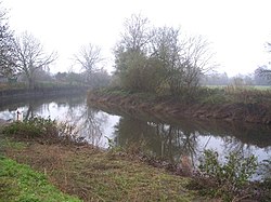
 The Severn at the 'White Horse', Walham | |
| Location | |
| Grid reference: | SO827193 |
| Location: | 51°52’44"N, 2°15’2"W |
| Data | |
| Postcode: | GL1 |
| Local Government | |
Walham is a village on the banks of the River Severn in Gloucestershire, beside the village of Longford (with which it shares a civil parish), to the north of Gloucester and of the A40 road.
The village is effectively a suburb of Gloucester, separated from the contiguous townscape only by the embanked course of the A40.
There is a National Grid substation in Walham providing power to half a million homes and the Government Communications Headquarters (GCHQ) in Cheltenham. The substation came to national prominence in July 2007, when it was threatened by a major flood from the Severn.[1] The fire service and military stopped the flood waters two inches below the height at which the plant would flood. This struggle with nature was dubbed the "Battle for Walham" in national newspapers.[1]
Battle for Walham
The Battle for Walham was the fight by emergency services and the Environment Agency to save the National Grid 400 kV substation at Walham. When the River Severn overflowed its banks during the Gloucestershire floods of 2007, the fire brigade, Army, Royal Navy, Royal Air Force and the Environment Agency joined forces to save the threatened substation.
The water came within two inches of overtopping the substation controls before receding. [1][2]
Outside links
| ("Wikimedia Commons" has material about Walham) |
References
- ↑ 1.0 1.1 1.2 'Saving Walham': Channel 4, 2007
- ↑ "Prime minister visits flood teams". BBC News. 25 July 2007. http://news.bbc.co.uk/1/hi/england/gloucestershire/6916010.stm.
