Snave
| Snave | |
| Kent | |
|---|---|
 Church of St Augustine | |
| Location | |
| Location: | 51°2’2"N, 0°52’10"E |
| Data | |
| Post town: | Ashford |
| Postcode: | TN26 |
| Local Government | |
| Council: | Ashford |
| Parliamentary constituency: |
Ashford |
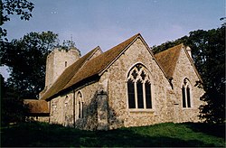
Snave is a very small hamlet in the hundred of Aloesbridge in Kent. It lies on Romney Marsh centred close to the A2070 road eight miles south of Ashford. Its buildings are a few houses, barns and store sheds and the church of St Augustine which holds one service per year at harvest festival. In spring, the churchyard is heavily clad in daffodils. The church falls under the ecumenical/ecclesiastical (Anglican/Methodist) parish of Hamstreet and Orlestone but the civil parish administering local services is Brenzett.
The nearest shops and railway station are at Hamstreet (three miles) save for a petrol station at Brenzett (two miles).
Animals have long been part of the economy. Sheep tending and wool manufacture is a major part of the history of Romney Marsh. Veterinary practices and a boarding cattery are among the local businesses.
Outside links

This Kent article is a stub: help to improve Wikishire by building it up.