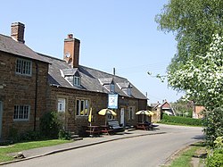
Oxhill, Warwickshire
| Oxhill | |
| Warwickshire | |
|---|---|
 Main Street | |
| Location | |
| Grid reference: | SP3145 |
| Location: | 52°6’38"N, 1°32’24"W |
| Data | |
| Population: | 305 (2011) |
| Post town: | Shipston-on-Stour |
| Postcode: | CV36 |
| Local Government | |
| Council: | Stratford-on-Avon |
Oxhill is a village in the Kington Hundred of Warwickshire, off the A422 road between Stratford-upon-Avon and Banbury. The population taken at the 2011 census was 305.[1] It lies in the area known as the Vale of the Red Horse. The village is mentioned in the Domesday Book as "Octeselve" and has a 12th-century church dedicated to Saint Lawrence.
The indentions in the chancel window mullions are believed by many to be the marks made by local archers sharpening their arrowheads. Because of the holiness and sacredness of the church, the blessed arrows were also presumed to have divine accuracy.[2]
In the graveyard of St Lawrence there is what is believed to be the only slave's grave in Warwickshire, that of a negro slave called Myrtilla.
References
- ↑ "Civil Parish population 2011". http://www.neighbourhood.statistics.gov.uk/dissemination/LeadKeyFigures.do?a=7&b=11127373&c=Oxhill&d=16&e=62&g=6472381&i=1001x1003x1032x1004&m=0&r=1&s=1451556913784&enc=1. Retrieved 31 December 2015.
- ↑ Drogin, Marc. 1989. Biblioclasm: The Mythical Origins. Savage, Maryland: Rowman and Littlefield. Pages 32-33.
Outside links
| ("Wikimedia Commons" has material about Oxhill, Warwickshire) |


This Warwickshire article is a stub: help to improve Wikishire by building it up.
