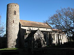
Bradwell, Suffolk
| Bradwell | |
| Suffolk | |
|---|---|
 Church of St Nicholas, Bradwell | |
| Location | |
| Grid reference: | TG504038 |
| Location: | 52°34’28"N, 1°41’39"E |
| Data | |
| Population: | 10,528 (2011) |
| Post town: | Great Yarmouth |
| Postcode: | NR31 |
| Local Government | |
| Council: | Great Yarmouth |
| Website: | Bradwell Parish Council |
Bradwell is a village and parish in the very north-east of Suffolk. The village is immediately to the west of, and largely indistinguishable from, the built-up urban area of the town of Great Yarmouth.[1] The civil parish had a population at the 2011 census of 10,528.[1] The village itself is situated just next to the town of Gorleston and the nearby beach.
Schools
Bradwell's schools include: Hillside Primary School, Homefield Church of England Primary and Nursery School, Lynn Grove High, and Woodlands Primary and Nursery School.
Parish Council
Bradwell Parish Council has responsibility for a number of amenities within the village. Its base is the Leo Coles Pavilion, located on the Green Lane Playing Field site – its meetings take place there, and the clerk's office is situated there. The council publishes a twice-yearly newspaper, ‘the Bradwellian’, which is delivered to every household in Bradwell by a team of volunteers.
References
- ^ Ordnance Survey (2005). OS Explorer Map OL40 - The Broads. ISBN 0-319-23769-9.
Outside links
| ("Wikimedia Commons" has material about Bradwell, Suffolk) |

This Suffolk article is a stub: help to improve Wikishire by building it up.
