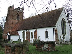
Wickham St Paul
| Wickham St Paul | |
| Essex | |
|---|---|
 All Saints' Church | |
| Location | |
| Location: | 51°59’46"N, 0°39’58"E |
| Data | |
| Post town: | Halstead |
| Postcode: | CO9 |
| Dialling code: | 01206 |
| Local Government | |
| Council: | Braintree |
Wickham St Paul is a village and parish located five miles north of Halstead in the Hinckford hundred of Essex.
The village, in which some of the houses surround a large open green (with cricket pitch and swings), contains a church, a public house, a part-time post office and a grocery store, part of a large farm shop and pick-your-own establishment.[1] The United Kingdom Census 2001 listed Wickham St Paul to have a population of 330.[1]
References
- ↑ 1.0 1.1 "Wickham St Paul". Braintree.gov.uk. http://www.braintree.gov.uk/Braintree/councildemocracy/Parish+Councils/Parish+Clusters/Castle+Hedingham/Wickham+St+Paul.htm. Retrieved 2010-07-23.

This Essex article is a stub: help to improve Wikishire by building it up.