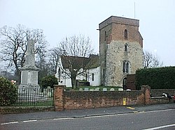
Bradfield, Essex
| Bradfield | |
| Essex | |
|---|---|
 Bradfield Church | |
| Location | |
| Grid reference: | TM144308 |
| Location: | 51°56’4"N, 1°7’30"E |
| Data | |
| Population: | 1,112 (2011[1]) |
| Post town: | Manningtree |
| Postcode: | CO11 |
| Dialling code: | 01206, 01255 |
| Local Government | |
| Council: | Tendring |
| Parliamentary constituency: |
North Essex |
Bradfield is a village and parish in Essex. It is located about three miles east of Manningtree and 31 miles north-east of the county town of Chelmsford. The village is in the Tendring peninsula and hundred. There is a Parish Council.[2] The 2001 National Census recorded a population of 1,094,[3] rising to 1,112 at the 2011 Census.[1]
The Anglican church is dedicated to Saint Lawrence. One of the windows[4] commemorates Edwin Harris Dunning, the first pilot to land an aircraft on a moving ship.
The village is close to the River Stour.
Bradfield is home to Bradfield Primary School.
References
| ("Wikimedia Commons" has material about Bradfield, Essex) |
- ↑ 1.0 1.1 "Civil Parish population 2011". Neighbourhood Statistics. Office for National Statistics. http://www.neighbourhood.statistics.gov.uk/dissemination/LeadKeyFigures.do?a=7&b=11121019&c=Bradfield&d=16&e=62&g=6425838&i=1001x1003x1032x1004&o=362&m=0&r=1&s=1443107062244&enc=1. Retrieved 24 September 2015.
- ↑ "Town and Parish Council and Clerks Details". www.tendringdc.gov.uk. http://www.tendringdc.gov.uk/TendringDC/Council/Town+and+Parish+Councils/Bradfield+Parish+Council.htm. Retrieved 25 January 2008.
- ↑ "2001 Census". neighbourhood.statistics.gov.uk. http://neighbourhood.statistics.gov.uk/dissemination/LeadTableView.do?a=7&b=794635&c=CO11+2XB&d=16&e=15&g=446649&i=1001x1003x1004&m=0&r=0&s=1201278122950&enc=1&dsFamilyId=779. Retrieved 25 January 2008.
- ↑ "National Maritime Memorial Register". www.nmm.ac.uk. Archived from the original on 8 June 2011. https://web.archive.org/web/20110608215532/http://www.nmm.ac.uk/memorials/Memorial.cfm?Topic=2&MemorialID=M1413. Retrieved 5 January 2008.

This Essex article is a stub: help to improve Wikishire by building it up.
