Upper Dean
| Upper Dean | |
| Bedfordshire | |
|---|---|
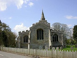
 Church of All Saints (or All Hallows) | |
| Location | |
| Grid reference: | TL046677 |
| Location: | 52°17’52"N, 0°28’2"W |
| Data | |
| Post town: | Huntingdon |
| Postcode: | PE28 |
| Dialling code: | 01234 |
| Local Government | |
| Council: | Bedford |
| Parliamentary constituency: |
North East Bedfordshire |
Upper Dean is a village in northern Bedfordshire, close to the borders of Northamptonshire and Huntingdonshire.
The village forms part of the Dean and Shelton civil parish, and is close to the settlements of Melchbourne and Swineshead. Upper Dean is the location of All Saints Church, a Grade-I listed church. It became a listed building on 13 July 1964.[1]
References
- ↑ "Church of All Saints, Upper Dean". British Listed Buildings. http://www.britishlistedbuildings.co.uk/en-36266-church-of-all-saints-dean-and-shelton. Retrieved 1 December 2011.

This Bedfordshire article is a stub: help to improve Wikishire by building it up.