Tarner Island
| Tarner Island | |
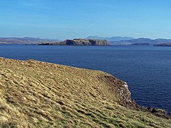
 Looking south east from Harlosh Point over Loch Bracadale | |
|---|---|
| Location | |
| Location: | 57°21’43"N, 6°29’35"W |
| Grid reference: | NG299391 |
| Highest point: | 184 ft[1] |
| Data | |
Tarner Island is a triangular shaped island in Loch Bracadale just off the coast off the Harlosh peninsula of Skye in Inverness-shire.[1][2] It is about 69 acres in extent. The coastline is largely cliff-lined and rocky and there is a natural arch to the north. Tarner Island is only about ⅔ mile from mainland Skye and there are several skerries including Sgeir Mhòr and Sgeir Bheag that lies just offshore to the north east between the island and Colbost Head.[1] Wiay and the tidal islet of Oronsay lie about a mile to the south.
Notes
- ↑ 1.0 1.1 1.2 "Get-a-Map". Ordnance Survey. Retrieved 9 December 2009.
- ↑ "Tarner Island". Gazetteer for Scotland. http://www.scottish-places.info/features/featurehistory1623.html. Retrieved 9 December 2009.
This Inverness-shire article is a stub: help to improve Wikishire by building it up.