Bradden
| Bradden | |
| Northamptonshire | |
|---|---|
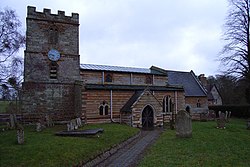
 St Michael's Church, Bradden | |
| Location | |
| Grid reference: | SP647483 |
| Location: | 52°7’48"N, 1°3’21"W |
| Data | |
| Population: | 149 (2011 Census) |
| Post town: | Towcester |
| Postcode: | NN12 |
| Dialling code: | 01327 |
| Local Government | |
| Council: | West Northamptonshire |
| Parliamentary constituency: |
Daventry |
Bradden is a village and parish in southern Northamptonshire, about four miles west of Towcester. According to the 2001 census it had a population of 179,[1] falling to 149 at the 2011 census.[2]
Buildings
The Parish Church is dedicated to St Michael and dates from the 13th century.[3]
There is a Manor House dated 1819 but there was an earlier pre-Reformation house before and, according to Pevsner, the front looks earlier than 1819.[3]
References
| ("Wikimedia Commons" has material about Bradden) |
- ↑ Office for National Statistics: Bradden CP: Parish headcounts. Retrieved 7 November 2009
- ↑ "Civil Parish population 2011". Neighbourhood Statistics. Office for National Statistics. http://www.neighbourhood.statistics.gov.uk/dissemination/LeadKeyFigures.do?a=7&b=11121014&c=Bradden&d=16&e=62&g=6452385&i=1001x1003x1032x1004&m=0&r=1&s=1467207784916&enc=1. Retrieved 29 June 2016.
- ↑ 3.0 3.1 Pevsner, Nikolaus; Cherry, Bridget (revision) (1961). The Buildings of England – Northamptonshire. London and New Haven: Yale University Press. pp. 118–9. ISBN 978-0-300-09632-3.

This Northamptonshire article is a stub: help to improve Wikishire by building it up.
