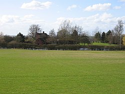
Stoneton
| Stoneton | |
| Northamptonshire | |
|---|---|
 Stoneton Manor | |
| Location | |
| Location: | 52°11’25"N, 1°18’55"W |
| Data | |
| Post town: | Southam |
| Postcode: | CV47 |
| Dialling code: | 01327 |
| Local Government | |
| Council: | Stratford-on-Avon |
Stoneton is a parish, hamlet and manor in Northamptonshire, adjacent to the border with Warwickshire. It lies just to the north-east of Wormleighton in that county and forms the westernmost part of its own.
The village was documented in the Domesday Book. From the late 15th century onwards the wealthy Spencer family owned land here, and owned the manor in conjunction with nearby Wormleighton Manor. Little remains of the original village, which lies in a field next to the manor.[1] The moat has been restored to Stoneton Manor, using water supplied from a nearby spring.
A windfarm with 8-13 turbines has been proposed in the vicinity since June 2012, with a capacity of up to 16MW of low-carbon energy.[2][3]
References
- ↑ "Wormleigton-Stoneton". BBC. http://www.bbc.co.uk/history/domesday/dblock/GB-444000-252000/page/7. Retrieved 25 May 2014.
- ↑ "Stoneton Wind Farm Proposal - Environmental Impact Assessment". Statford-on-Avon District Council. https://www.stratford.gov.uk/planning/environmental-impact-assessment--stoneton.cfm. Retrieved 25 May 2014.
- ↑ "Project Overview". EDF. http://www.edf-er.com/OurProjects/Proposed/Stoneton/ProjectOverview.aspx. Retrieved 25 May 2014.

This Northamptonshire article is a stub: help to improve Wikishire by building it up.