Kinnerton
| Kinnerton | |
| Radnorshire | |
|---|---|

| |
| Location | |
| Location: | 52°15’41"N, 3°6’35"W |
| Data | |
| Post town: | Presteigne |
| Postcode: | LD8 |
| Dialling code: | 01547 |
| Local Government | |
| Council: | Powys |
| Parliamentary constituency: |
Brecon & Radnorshire |
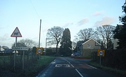
Kinnerton is a hamlet in the ancient parish of Old Radnor, Radnorshire. It is situated on the B4372 road between New Radnor and Beggar's Bush where it joins the B4357.
The Church of England church of St Mary is located in the centre of the village in a raised churchyard used as a cemetery. It was built in 1884-5 in lancet style to designs of Thomas Nicholson. Although the church is an entirely nineteenth-century construction it replaced an earlier church that had been enlarged and refitted in 1833-4. it is part of the Diocese of Hereford.
This Radnorshire article is a stub: help to improve Wikishire by building it up.