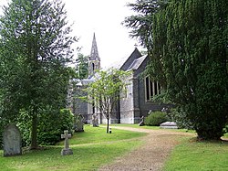
Ampfield
| Ampfield | |
| Hampshire | |
|---|---|
 St Mark's Church | |
| Location | |
| Grid reference: | SU406237 |
| Location: | 51°-0’41"N, 1°25’21"W |
| Data | |
| Population: | 1,474 (2001) |
| Post town: | Romsey |
| Postcode: | SO51 |
| Dialling code: | 01794 |
| Local Government | |
| Council: | Test Valley |
| Parliamentary constituency: |
Romsey |
Ampfield is a village and parish in Hampshire, between Romsey, Eastleigh, and Winchester. It had a population at the 2001 census of 1,474.[1]
Ampfield lies on sands and clays of Eocene age near the northern edge of the Hampshire Basin. Ampfield Wood on the London Clay[2] to the north of the village is crossed by the Monarch's Way long-distance footpath. The parish includes the hamlets of Knapp and Gosport.
The author of the Thomas the Tank Engine series of books, Rev. W Awdry, was born in Ampfield Vicarage.
Potters Heron Hotel
The Potters Heron Hotel is situated in Ampfield Village. Its Thatch Roof is well known and loved amongst many.
Outside links
| ("Wikimedia Commons" has material about Ampfield) |
References
- ↑ "Parish Headcounts, Area: Ampfield CP". Neighbourhood Statistics. Office for National Statistics. 2001. http://www.neighbourhood.statistics.gov.uk/dissemination/LeadTableView.do?a=3&b=795133&c=Ampfield&d=16&e=15&g=452673&i=1001x1003x1004&o=1&m=0&r=1&s=1205083470203&enc=1&dsFamilyId=779. Retrieved 2008-03-09.
- ↑ British Geological Survey (2002), Winchester. England and Wales Sheet 299. Solid and Drift Geology, 1:50,000 Series geological map, Keyworth, Nottingham: British Geological Survey, ISBN 0-7518-3340-1

This Hampshire article is a stub: help to improve Wikishire by building it up.
