Walderton
| Walderton | |
| Sussex | |
|---|---|
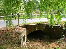
 River Ems, Walderton | |
| Location | |
| Grid reference: | SU790106 |
| Location: | 50°53’25"N, -0°52’38"W |
| Data | |
| Post town: | Chichester |
| Postcode: | PO18 |
| Local Government | |
| Council: | Chichester |
| Parliamentary constituency: |
Chichester |
Walderton is a hamlet in the parish of Stoughton, Sussex. It lies on the B2146 road four miles north-east of Emsworth. The population taken at the 2011 Census was included in the civil parish of Stoughton.
The village lies just below the source of the River Ems. It is crossed by the Monarch's Way long distance footpath.
| ("Wikimedia Commons" has material about Walderton) |

This Sussex article is a stub: help to improve Wikishire by building it up.
