Ratoath
| Ratoath Irish: Ráth Tó | |
| Meath | |
|---|---|
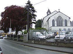
 Ratoath – Holy Trinity church | |
| Location | |
| Grid reference: | O016519 |
| Location: | 53°30’22"N, 6°27’47"W |
| Data | |
| Population: | 9,043 (2011[1]) |
| Post town: | Ratoath |
| Postcode: | A85 |
| Local Government | |
| Council: | Meath |
| Dáil constituency: |
East Meath |
Ratoath is a town in the barony same name in Meath. The town is centred on the point where the R125 and R155 regional roads meet. In the 1996 census, the population was recorded as 1,061. In the 2006 census, it was 7,249. By 2011 the population reached 9,043. The Broad Meadow River flows through the town, which takes its name from the Irish Ráth Tó, meaning "Tó's ringfort".[2]
Ratoath is a commuter town with most of its adult population commuting to Dublin to work. More than three quarters of the population travelled to work by car.
Just outside the town is the horse racing track Fairyhouse Racecourse, where the Irish Grand National is held.
Ratoath gives its name to a village, a townland, a parish, an electoral division and to a barony. The derivation or meaning of the word is uncertain. Two alternative Irish forms are cited: Ráth-Tógh and Ráth-Tábhachta. These placenames occur in Irish manuscripts and scholars say that the writers were referring to Ratoath. Evidently they were trying to give a phonetic rendering of a name that was unfamiliar to them. Mruigtuaithe occurs in the Book of Armagh as the name of one of these places in Meath where Saint Patrick founded a church and Eoin MacNeill identifies it as Ratoath. If this is correct it would seem that the second portion of the word comes from the Irish word tuath which means a territory belonging to a family or sept. Mruig means a grazing plain. Ráth is the Irish for a ringfort. In a royal grant of land in 1468 it was described as Rathonth.
References
- ↑ "Census 2006 – Volume 1 – Population Classified by Area" (PDF). Central Statistics Office Census 2006 Reports. Central Statistics Office Ireland. April 2007. http://www.cso.ie/census/documents/census2006_volume_1_pop_classified_by_area.pdf. Retrieved 2011-06-05.
- ↑ Logainm.ie: Irish Placenames Database
| ("Wikimedia Commons" has material about Ratoath) |
