Warslow
| Warslow | |
| Staffordshire | |
|---|---|
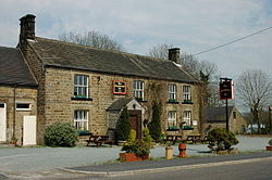
 The Greyhound at Warslow | |
| Location | |
| Grid reference: | SK086586 |
| Location: | 53°7’31"N, 1°52’18"W |
| Data | |
| Population: | 320 (2011[1]) |
| Post town: | Buxton |
| Postcode: | SK17 |
| Local Government | |
| Council: | Staffordshire Moorlands |
| Parliamentary constituency: |
Staffordshire Moorlands |
Warslow is a small village in northern Staffordshire. It is located in the Peak District National Park about ten miles north of Ashbourne, Derbyshire.
The village has a village hall, pub, two chapels and a church. The church, St Lawrence, has an unusually wide chancel and windows by William Morris. The two chapels have both been converted for residential use.
There are numerous fresh water springs located within the village and at one time this water was bottled and sold.
The village has a single public house, The Greyhound and Hare, which dates back to around 1750. The Greyhound and Hare is located roughly in the centre of the village.
References
| ("Wikimedia Commons" has material about Warslow) |

This Staffordshire article is a stub: help to improve Wikishire by building it up.
