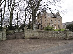
Beal, Northumberland
| Beal | |
| Northumberland | |
|---|---|
 Beale House | |
| Location | |
| Grid reference: | NU065427 |
| Location: | 55°40’37"N, 1°53’49"W |
| Data | |
| Post town: | Berwick-Upon-Tweed |
| Postcode: | TD15 |
| Dialling code: | 01289 |
| Local Government | |
| Council: | Northumberland |
| Parliamentary constituency: |
Berwick-upon-Tweed |
Beal is a village in northern Northumberland, just a short distance inland from the North Sea coast. It is on the link road which runs east off the A1 towards Lindisfarne.
The East Coast Main Line runs to the west of the village but the station was closed in the 1960s. The station site has been landscaped and includes a Peckett 0-4-0ST steam locomotive and an ex-North Eastern Railway cast metal warning sign.
History
The place-name Beal is first attested in 1208-10, where it appears as Behil. In 1248 it appears as Behulle. The name derives from the Old English 'beo-hyll', which means 'bee hill'.[1]
Economy
The area is largely agricultural in outlook.
There is a pub at Beal situated on the main road called The Lindisfarne Inn. It re-opened after being refurbished and was renamed having previously been named The Plough.[2]
The Barn at Beal is a visitor centre with various wild birds and looks at the link between farming and the local environment.[3]
There is a small caravan site located at Brock Mill farmhouse [4] and there are a number of bed-and-breakfast outlets.
Outside links
| ("Wikimedia Commons" has material about Beal, Northumberland) |
References
- ↑ Eilert Ekwall, The Concise Oxford Dictionary of English Place-names, p.32.
- ↑ Northumberland Gazette: The Lindisfarne Inn, Beal
- ↑ http://barnatbeal.com/
- ↑ http://www.lindisfarne.org.uk/brock-mill-farmhouse/index.htm
