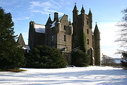
Balintore, Angus
| Balintore | |
| Angus | |
|---|---|
 Balintore Castle | |
| Location | |
| Grid reference: | NO287590 |
| Location: | 56°43’2"N, 3°9’59"W |
| Data | |
| Post town: | Kirriemuir |
| Postcode: | DD8 |
| Dialling code: | 01575 |
| Local Government | |
| Council: | Angus |
| Parliamentary constituency: |
Angus |
Balintore is a village in Angus. It lies in Glen Isla, four miles north of the Loch of Lintrathen and seven miles west of Kirriemuir.[1] Approximately half a mile to the east is Knowehead of Auldallan farm, where there can be found a pair of uninscribed standing stones.[2]
References
- ↑ "Dundee and Montrose, Forfar and Arbroath", Ordnance Survey Landranger Map, 2007, ISBN 0-319-22980-7
- ↑ "Auldallan". The Megalithic Portal. http://www.megalithic.co.uk/modules.php?op=modload&name=a312&file=index&do=showpic&pid=1993. Retrieved October 5, 2010.
This Angus article is a stub: help to improve Wikishire by building it up.