Inchinnan
| Inchinnan | |
| Renfrewshire | |
|---|---|
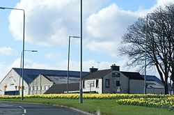
 Daffodils in Inchinnan | |
| Location | |
| Grid reference: | NS475691 |
| Location: | 55°53’30"N, 4°26’19"W |
| Data | |
| Population: | 1,574 (2011) |
| Post town: | Renfrew |
| Postcode: | PA4 |
| Dialling code: | 0141 |
| Local Government | |
| Council: | Renfrewshire |
| Parliamentary constituency: |
Paisley & Renfrewshire North |
Inchinnan is a small village in Renfrewshire, on the main A8 road between Renfrew and Greenock, just south east of the town of Erskine.
Inchinnan is in the north-east of Renfrewshire. It stands to the south of the River Clyde and close to where the River Gryffe meets the River Cart. The village borders a number of nearby settlements, some separated by a rural hinterland.
History
The name of Inchinnan village is derived from the Gaelic word 'Innis', which means an island or low-lying land near a river or stream. The other part of the name is taken from Saint Inan, a 9th-century confessor at Irvine.[1] A church has been located in Inchinnan since the 12th century. It was dedicated to St Conval and was given to the Knights Templar by King David I. Another church called 'Hallows Church' replaced it in 1900. The newer church was then replaced by part of the airfield at Abbotsinch.[2] The latest church (Inchinnan Parish) is in the centre of the village.
The two main rivers which form the River Cart, the Black Cart Water and the White Cart Water, flow near Inchinnan. Travellers crossed each by a ford and later by ferry. A stone bridge was built to cross the Black Cart and a bascule bridge crosses the White Cart.[3]
In the 1700s there were quarries within the village. The quarries produced high quality freestone right up until the 1900s. In 1809-1812 stone from the quarries built the nearby Black and White Cart bridges.[4]
Landmarks


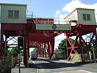
The White Cart Bridge, a swing bridge over that river, was replaced in 1923 by a bascule bridge, which was made by Sir William Arrol & Company. It is still capable of opening, as the Doosan Babcock factory at Renfrew requires the capability to move large loads by river.
Inchinnan hosts an art deco style category A listed building called India of Inchinnan. It is the former office block of India Tyres factory which occupied the site from 1927 until the early 1980s. It has now been renovated into private offices. The company also built two groups of houses to accommodate its workers. These streets were called Allands Avenue and India Drive. Prior to its use as a tyre factory, the site was used by William Beardmore and Company to build airships during the First World War. Several airships, the No's R24, R27, R34 and the R36 were built on this site. The company built 52 houses in Inchinnan, at Beardmore Cottages, to house its workers.
Inchinnan has a large industrial estate within the town. There is a few manufacturing companies left within the area. Some of the companies associated with Inchinnan past and present include: 'Reekie Machine Tools', 'Scot Tubes Ltd', 'Gas Measurement Instruments', 'Bairdswear', 'Armour Park', 'Metecno', 'Aulds' and 'Rolls Royce'. M&Co. (Mackays) has its head office at Caledonia House in the industrial estate.
There is a bus depot in Inchinnan which belonged to Arriva Scotland West and before that Western SMT (later Clydeside Scottish). In December 2011, it was announced that Arriva had agreed to sell the company to the independent operator McGill's Buses and all of Arriva Scotland West's operations ceased on Monday 26 March 2012.
East of the village beside the A8 road is a spoil tip from a disused ironstone mine. This hillock is now covered with trees. The mine, known as the Blythswood mine was abandoned by 1875.
A palace was situated within the village about 1506. It was built by Matthew, Lord Darnley, second Earl of Lennox. Remains of the building known as Palace of Inchinnan could be seen up to 1710 but have now since been destroyed. It was situated on the border with Erskine; near to Flures Drive in Erskine.[5]
The Inchinnan Cruising club was established in 1932. It is sited east of the village.[6]
Gallery
-
Inchinnan Cruising Club
-
Bus Depot
-
Park Hall Nursery
-
Rolls-Royce Factory
Outside links
| ("Wikimedia Commons" has material about Inchinnan) |
References
- ↑ "Free Scottish family tree inscriptions and links from HappyHaggis". HappyHaggis.. http://www.happyhaggis.co.uk/renfrewshire.htm. Retrieved 2014-07-21.
- ↑ CANMORE (RCAHMS) record of Inchinnan, Old Parish Church And Graveyard All Hallows Church; St Conval's
- ↑ "Inchinnan - Renfrewshire Council". Renfrewshire.gov.uk. http://www.renfrewshire.gov.uk/webcontent/home/services/leisure+and+culture/heritage+and+local+history/els-inchinnan(ourhistoryandheritage). Retrieved 2014-07-10.
- ↑ "FREE Scottish family tree inscriptions and links from HappyHaggis". HappyHaggis.. http://www.happyhaggis.co.uk/renfrewshire.htm. Retrieved 2014-07-21.
- ↑ "FREE Scottish family tree inscriptions and links from HappyHaggis". HappyHaggis.. http://www.happyhaggis.co.uk/renfrewshire.htm. Retrieved 2014-07-21.
- ↑ "History « Inchinnan Cruising Club". Inchinnancruisingclub.co.uk. 1933-04-12. http://www.inchinnancruisingclub.co.uk/?page_id=2. Retrieved 2014-07-11.
- Gregory, Donald (1881) The History of the Western Highlands and Isles of Scotland 1493 - 1625. Edinburgh. Birlinn. 2008 reprint - originally published by Thomas D. Morrison. ISBN 1-904607-57-8
- Johnson, Ian, (1993). Beardmore Built: The Rise and Fall of a Clydeside Shipyard. Clydebank: Clydebank District Libraries & Museums Department.
- Wool, Alex "The Age of the Sea-Kings: 900-1300" in Omand, Donald (ed.) (2006) The Argyll Book. Edinburgh. Birlinn. ISBN 1-84158-480-0


