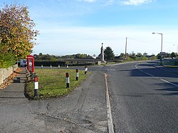
Marsh Lane, Derbyshire
| Marsh Lane | |
| Derbyshire | |
|---|---|
 Main Road, Marsh Lane | |
| Location | |
| Grid reference: | SK406791 |
| Location: | 53°18’29"N, 1°23’31"W |
| Data | |
| Postcode: | S21 |
| Local Government | |
| Council: | North East Derbyshire |
Marsh Lane is a village of north-eastern Derbyshire, close by Eckington (to whose parish it has been allocated).[1] It is six miles north-east of Chesterfield, and a little south of the edge of the suburbs of Sheffield which here spill over into Derbyshire. In 2011 the village had a population of 895.
There is a primary school here, built in the 1870s, and also a nursery school.
Culture
As the village is located just between the border of Derbyshire with the West Riding of Yorkshire, the village has its own accent. It is said to be a cross between the distinctive Sheffield accent and that of [[Chesterfield], Chesterfield's being the predominant.
Outside links
- Marsh Lane: Peak District Online