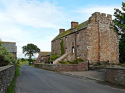
Drumburgh Castle
| Drumburgh Castle | |
|
Cumberland | |
|---|---|
 Drumburgh Castle | |
| Type: | Pele tower |
| Location | |
| Grid reference: | NY265597 |
| Location: | 54°55’36"N, 3°8’54"W |
| History | |
| Built 1518 | |
| Information | |
Drumburgh Castle is a medieval pele tower in the village of Drumburgh, on the Eden estuary at the head of the Solway Firth in Cumberland.
History
A pele tower was originally built on this site, near Burgh, by Robert le Brun in 1307, on the site of a former tower that had been part of Hadrian's Wall.[1][2] The construction used red sandstone masonry from the wall for its construction.[2]
Thomas Dacre rebuilt the castle in 1518, producing what contemporaries described as "neither castle nor tower but a house of strength".[2] The house was altered again between 1678 to 1681 by John Alglionby, leaving it in its current design.[1] The property today has a distinctive first floor doorway and staircase - a later addition to the castle - decorated with the Dacre coat of arms, and has parts of a Roman shrine incorporated into its stonework.[3]
References
- Pettifer, Adrian: 'English Castles: a Guide by Counties' (Boydell Press, 2002) ISBN 978-0-85115-782-5
- Richards, Mark and Roger Clegg: 'The Spirit of Hadrian's Wall' (Cicerone Press, 2008) ISBN 978-1-85284-558-2