Belnahua
| Belnahua Gaelic: Beul na h-Uamha | |
 Belnahua | |
|---|---|
| Location | |
| Location: | 56°15’0"N, 5°41’24"W |
| Grid reference: | NM713127 |
| Highest point: | 72 ft |
| Data | |
| Population: | 0 |
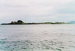
Belnahua is one of the Slate Islands, in the Firth of Lorn in Argyllshire, known for its slate quarries. The name is from the Gaelic Beul na h-Uamha, meaning 'The mouth of the cave'. It lies a mile and a half north-west of Luing, and east of the Garvellachs. Although it once had a population of nearly 200 people, it has been uninhabited since World War I. Famed for its slate, the island has been considerably denuded by its quarrying. Deep water-filled cuttings and the ruined slate workers cottages remain as a testament of this industry.[1]
There was a jetty to the east of the island, but it has been worn away within the last quarter of the twentieth century, and an extensive drying reef to the north-west.[2] The Latvian vessel Helena Faulbaums foundered on the reef in 1936, with the loss of 16 lives.[3]
A quiet home for local wildlife, the island is occasionally a stop off for local fisher folk and tourists. It is currently owned by the Carling family.[3]
Footnotes
- ↑ "Overview of Belnahua". Gazetteer for Scotland. http://www.scottish-places.info/features/featurefirst1527.html. Retrieved 28 July 2007.
- ↑ Ordnance Survey
- ↑ 3.0 3.1 Haswell-Smith, Hamish (2004). The Scottish Islands. Edinburgh: Canongate.
| ("Wikimedia Commons" has material about Belnahua) |
| The Slate Islands |
|---|
|
Belnahua • Easdale • Fladda • Luing • Lunga • Seil • Shuna • Torsa |
