Glevum


Glevum (or, more formally, Colonia Nervia Glevensium, or occasionally Glouvia) was originally a fort in Roman Britain that became a "colonia" of retired legionaries in AD 97. Today, it is known as Gloucester, the county town of Gloucestershire. The name 'Glevum' is taken by many present-day businesses in the area and also by the 26-mile Glevum Way,[1] a long-distance footpath or recreational walk encircling modern Gloucester.
Fortress
Glevum was established around AD 48, at an important crossing of the River Severn, and near to the Fosse Way, the early front line after the Roman advance through Britain. Initially, a Roman fort was established at present-day Kingsholm in c. AD 65–70.[2]
The legions based here were probably the Legio XX Valeria Victrix until 66 and then Legio II Augusta[3] for their invasion of the western mountains between AD 66 and 74.[4]
Between AD 81 and 98, larger replacement walls were built on slightly higher ground nearby, centred on present-day Gloucester Cross which was probably part of the change from a military fort to a walled colonia after the Legio II Augusta had been transferred to Caerleon. The civilian settlement also grew outside the walls.[5]
Colonia
In AD 97, the city was designated a 'colonia' by the Emperor Nerva. A colonia was the residence of retired legionaries and enjoyed the highest status of city in the Empire. The legionaries were given farmland in the surrounding district, and could be called upon as a Roman auxiliary armed force.
The city was built within the legionary fortress and used the same rectilinear street plan and ramparts.[6] A large and impressive administrative basilica and forum market-place were built in the town, as well as many fine homes with mosaic floors.
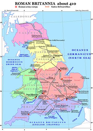
Roman Britain was divided into four provinces in the early 4th century. It is most likely that Glevum, as a colony, became the provincial capital of Britannia Secunda, in the same way that colonies at York and Lincoln became capitals of their respective provinces. There is some evidence that at this time Glevum possessed a mint.[4]
The Roman wharf where goods were shipped via an inlet from the River Severn has been excavated at Upper Quay Street and which dendrochronological dating has shown was built from AD 74.[7]
At its height, Glevum may have had a population of as many as 10,000 people.
The entire area around Glevum was intensely Romanised in the second and third centuries, with a higher than normal distribution of villas, as a result of its suitability for the traditional intensive Roman farming methods. Today, some of the best examples of Roman villas in Britain, including Chedworth villa and Woodchester villa, both famous for their Roman mosaics, are not far from Glevum.
Decline
Excavations at Gloucester's New Market Hall in the 1960s[8][9] showed that Romano-British occupation of the town may have continued in some form into the sub-Roman period, even if the town's population may have been greatly reduced. A new portal in the town's wall was built at the beginning of the sixth century, showing a modest growth of the town.
The Anglo-Saxon Chronicle records a King Coinmail (according to the original A-text), who may have come from Gloucester, taking part in the Battle of Dyrham in 577, which battle allowed the city to be conquered by the Saxons.
Remains

- Many archaeological artefacts and some in situ walls from Roman Glevum may be seen in the Gloucester City Museum and Art Gallery
- The remains of the Roman and medieval East Gate are on display in the East Gate Chamber on Eastgate Street.
- There was a small display in the former Royal Bank of Scotland premises on the Roman finds found from the site, but the branch has now closed and the building is currently empty.
- Northgate, Southgate, Eastgate and Westgate Streets all follow the line of their original Roman counterparts, although Westgate Street has moved slightly north and Southgate Street now extends through the site of the Roman basilica.
Outside links
References
- ↑ Glevum Way Summary - the Long Distance Walkers Association
- ↑ New discoveries along the line of Gloucester’s Roman defences https://cotswoldarchaeology.co.uk/all-along-the-watchtower-new-discoveries-along-the-line-of-gloucesters-roman-defences/
- ↑ G Webster, Rome against Caractacus, p 45, ISBN 978-07-13436-27-3
- ↑ 4.0 4.1 Glevum: Gloucestershire Archæology]
- ↑ New discoveries along the line of Gloucester’s Roman defences https://cotswoldarchaeology.co.uk/all-along-the-watchtower-new-discoveries-along-the-line-of-gloucesters-roman-defences/
- ↑ J. Wacher, The Towns of Roman Britain, ISBN 9780415170413 p 137-
- ↑ Two thousand years of development in Gloucester’s Greater Blackfriars area: Cotswold Archaeology
- ↑ Hassall, M; Rhodes, J (1974). "Excavations at the new Market Hall, Gloucester 1966-7". Trans Bristol Gloucestershire Archaeol Soc 93: 15–100.
- ↑ Wallace, Collin: 'Makers' Stamps on Mortaria from Gloucester' Study Group for Roman Pottery