Long Bredy
| Long Bredy | |
| Dorset | |
|---|---|
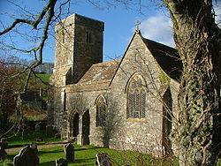
 St Peter's church, Long Bredy | |
| Location | |
| Grid reference: | SY569903 |
| Location: | 50°42’30"N, 2°36’42"W |
| Data | |
| Population: | 208 (2011) |
| Post town: | Dorchester |
| Postcode: | DT2 |
| Local Government | |
| Council: | Dorset |
| Parliamentary constituency: |
West Dorset |
Long Bredy is a village in Dorset, situated approximately seven miles west of the county town of Dorchester. It is sited in the valley of the small River Bride, beneath chalk hills of the Dorset Downs. In the 2011 census the parish had a population of 208.
The environs of Long Bredy have some prehistoric history, including a burial chamber known as The Grey Mare and her Colts.
The village itself is thought to have been established around the 9th century, and in 1086 was recorded in the Domesday Book as 'Langebride', which would have been pronounced 'Langabridda'.[1] To the east of the village is Kingston Russell house, a 17th-century mansion.
Bottle Knap Cottage, owned by the National Trust, is a Grade-II listed building.[2] In May 2013 the remains of two human skeletons were discovered in a completely unexpected location[3] and later radiocarbon dating gave a likely age between 800 and 600 BC. Martin Papworth, an archaeologist with the National Trust, said, "The remains are of three teenage or young adults, probably crouched, are all from around the period when the first iron was being used in this country. No other burials in Dorset have been identified from this time."[4]
Outside links
| ("Wikimedia Commons" has material about Long Bredy) |
References
- ↑ C. J. Bailey (1982). "Extracts from C.J. Bailey's Book "The Bride Valley"". www.burtonbradstock.org.uk. http://www.burtonbradstock.org.uk/History/C%20J%20Baileys%20The%20Bride%20Valley/The%20Natural%20Setting.htm. Retrieved 1 March 2014.
- ↑ National Heritage List 1118679: Bottle Knap Cottage, Long Bredy
- ↑ "Lacock". https://archaeologynationaltrustsw.wordpress.com/tag/lacock/.
- ↑ "Ancient bones found in West Dorset dig are 'significant find'". https://www.dorsetecho.co.uk/news/13629807.ancient-bones-found-in-west-dorset-dig-are-significant-find/.
