Exton, Somerset
| Exton | |
| Somerset | |
|---|---|
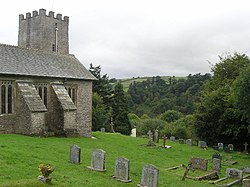
 St Peter's Church, Exton | |
| Location | |
| Grid reference: | SS925335 |
| Location: | 51°5’27"N, 3°32’11"W |
| Data | |
| Population: | 243 (2011) |
| Post town: | Dulverton |
| Postcode: | TA22 |
| Dialling code: | 01643 |
| Local Government | |
| Council: | Somerset West and Taunton |
| Parliamentary constituency: |
Bridgwater & W. Somerset |
Exton is a village five miles north-east of Dulverton and nine miles south-west of Dunster in Somerset. It stands by the River Exe on Exmoor, and within the Williton and Freemanners Hundred.
The wider parish includes the village of Bridgetown and is all of which is within the Exmoor National Park.
History

Edbrooke Bridge over the River Exe is mediæval in origin.[1]
In the Middle Ages the manor passed with the forestership of the Royal Forest of Exmoor, later being owned by the Rollers and then the Siderfins of Croydon who sold it in 1700, following a private Act of parliament in 1698.[2]
Church
The parish church is St Peter's; a Norman church with a 13th-century tower. It is a Grade II* listed building.[3]
Outside links
| ("Wikimedia Commons" has material about Exton, Somerset) |
References
- ↑ National Heritage List 1295874: Edbrooke Bridge
- ↑ Bush, Robin (1994). Somerset: The Complete Guide. Dovecote Press. pp. 98. ISBN 1-874336-26-1.
- ↑ National Heritage List 1296311: Church of St Peter, Exton
