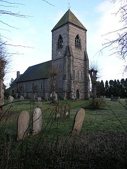
Foston and Scropton
| Foston and Scropton | |
| Derbyshire | |
|---|---|
 St Paul's parish church | |
| Location | |
| Grid reference: | SK1930 |
| Location: | 52°52’8"N, 1°42’50"W |
| Data | |
| Population: | 728 (2001[1]) |
| Post town: | Derby |
| Postcode: | DE65 |
| Dialling code: | 01283 |
| Local Government | |
| Council: | South Derbyshire |
| Parliamentary constituency: |
South Derbyshire |
| Website: | Foston and Scropton Parish Council |
Foston and Scropton is a civil parish in the Dove valley in southern Derbyshire, adjacent to the border with Staffordshire. It comprises the townships of Scropton and Foston, which together form the ancient parish of Scropton. The population of the civil parish at the 2001 Census was 728 increasing to 854 at the 2011 Census.[2]
The Domesday book records that in 1086 Henry de Ferrers held a manor here.[3]
The Church of England parish church of Saint Paul, Scropton contains late 15th- and early 16th-century monuments.[4] However, the church was rebuilt in 1855–56 under the direction of the Gothic Revival architect Benjamin Ferrey.[4] The village of Scropton has no shop or pub put it does have a large house called the old school house.
Economy
Scropton's Cranberry Foods is the second largest turkey processor in the UK after Bernard Matthews Ltd. Foston is home to JCB Power Systems, and a large dairy.
References
- ↑ "Area selected: South Derbyshire (Non-Metropolitan District)". Neighbourhood Statistics: Full Dataset View. Office for National Statistics. http://neighbourhood.statistics.gov.uk/dissemination/viewFullDataset.do?instanceSelection=03070&productId=779&$ph=60_61&datasetInstanceId=3070&startColumn=1&numberOfColumns=4&containerAreaId=790358. Retrieved 29 September 2011.
- ↑ "Civil Parish population 2011". Neighbourhood Statistics. Office for National Statistics. http://www.neighbourhood.statistics.gov.uk/dissemination/LeadKeyFigures.do?a=7&b=11123548&c=Foston+and+Scropton&d=16&e=62&g=6414955&i=1001x1003x1032x1004&m=0&r=1&s=1458819096424&enc=1. Retrieved 24 March 2016.
- ↑ Domesday Book
- ↑ 4.0 4.1 Pevsner & Williamson, 1978, page 315
Sources
- Pevsner, Nikolaus; Williamson, Elizabeth (1978) [1953]. Derbyshire. The Buildings of England. Harmondsworth: Penguin Books. p. 315. ISBN 0-14-071008-6.
| ("Wikimedia Commons" has material about Foston and Scropton) |

This Derbyshire article is a stub: help to improve Wikishire by building it up.
