Bourtie
| Bourtie | |
| Aberdeenshire | |
|---|---|
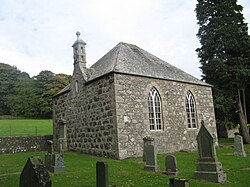
 Bourtie parish church | |
| Location | |
| Location: | 57°18’51"N, 2°19’44"W |
| Data | |
| Population: | 276 |
| Post town: | Inverurie |
| Postcode: | AB51 |
| Dialling code: | 01651 |
| Local Government | |
| Council: | Aberdeenshire |
Bourtie is a parish in the Garioch district of Aberdeenshire, to the south of Old Meldrum. Records show that there has been a parish church in Bourtie since at least 1190, but the present church, situated in Kirkton of Bourtie in the centre of the parish dates from 1806.
On the north, it is bounded by Daviot, Meldrum, and Tarves; and on the south, by Udny and Keithhall and Kinkell. Near the centre of the parish, and distant a mile from each other, rise two hills of considerable elevation. The northerly of the two is the Hill of Barra (626 ft), the other being Lawel Hill (774 ft). These run in an easterly direction and converge at the Hill of Kingoody on the eastern edge of the parish.
| ("Wikimedia Commons" has material about Bourtie) |
This Aberdeenshire article is a stub: help to improve Wikishire by building it up.